4 public housing estates to be zoned as car-lite areas, prioritising public facilities, green spaces
Sign up now: Get ST's newsletters delivered to your inbox
Follow topic:
SINGAPORE - Four public housing estates - Ulu Pandan, Mount Pleasant, Tengah and the Greater Southern Waterfront - will be gazetted as car-lite in a push towards sustainability.
Two other areas, Pearl's Hill and Tanjong Rhu, will also be gazetted.
The change for all six will come into effect on Oct 31.
Car-lite areas are planned upfront with public transport, walking and cycling connections, allowing for the provision of fewer parking spaces, said the Housing Board and Land Transport Authority (LTA) on Wednesday.
HDB will reduce the number of parking spaces in selected precincts within the gazetted car-lite areas to free up space for public facilities and greenery. Parking spaces will be prioritised for residents in these precincts.
The first Build-To-Order (BTO) flats in Ulu Pandan will be launched in the November sales exercise, and it will be the first HDB car-lite precinct.
HDB announced in July 2021 that it would be developing the eastern half of Ulu Pandan, with new public housing projects to be designed to weave in greenery and blue elements in the area.
Water-sensitive urban design, including elements such as rain gardens and bioswales (channels to treat surface water run-off), will also be integrated into the new housing precincts.
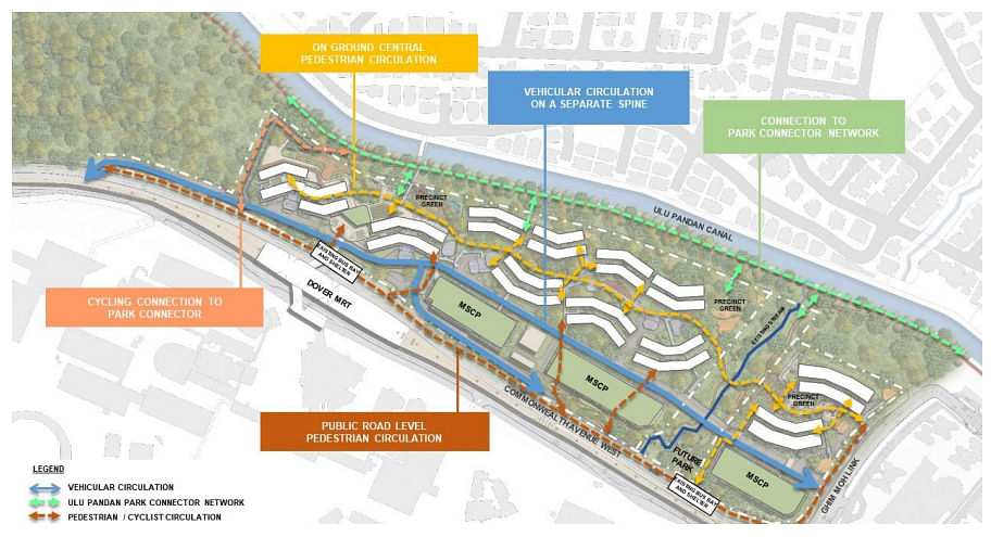
Residents can use sheltered elevated linkways to get to Dover MRT station, and there will be barrier-free access to bus stops along Commonwealth Avenue.
Vehicular roads will be located at the perimeter of the precincts, away from the main pedestrian walkway.

The number of parking spaces will be reduced in precincts located near Dover MRT station to free up space for shared community spaces, pedestrian and cycling paths, parks and greenery, said the authorities.
"Upon completion of Ulu Pandan's housing development, HDB will continue to monitor parking demand and refine our parking measures, if necessary," they added.
About 6,000 HDB flats will be built on the Keppel Club site in the Greater Southern Waterfront, with the first BTO project to be launched for sale within three years.
Mount Pleasant will have around 5,000 HDB flats, and the first BTO project there is expected to be launched within five years.
About 20 per cent of the land in Tengah will be dedicated to green spaces. When fully developed, the town will provide about 42,000 new homes.
ERA Realty’s head of research and consultancy Nicholas Mak said more Singaporeans are environmentally conscious and may be open to not owning a car.
“While owning a car is still a preference among many Singaporeans, the rising COE (certificate of entitlement) prices favour a car-lite push. People will be accepting of car-lite towns as long as there’s accessibility and ease of travel at a reasonable cost,” he said.
“This concept is anticipating and catering to the growing number of Singaporeans who care about the environment.”
There are 10 gazetted car-lite areas: Kampong Bugis, Marina South, Jurong Lake District, Bayshore, Woodlands North, Jurong Innovation District, one-north, Punggol Digital District, Springleaf and Woodlands Central.
The car-lite boundary in Bayshore will also be expanded from Oct 31, said an LTA circular, citing “potential synergies” between the original gazetted area and the adjacent development areas.
Wednesday’s announcement is the next step in the push for a car-lite nation, among other initiatives such as expanding the islandwide cycling path network from the current 500km to about 1,300km by 2030.
Other plans in the pipeline include the Cross Island Line - Singapore’s longest fully underground line connecting Jurong Lake District, Punggol Digital District and the Changi region - which is slated to open by 2032.

