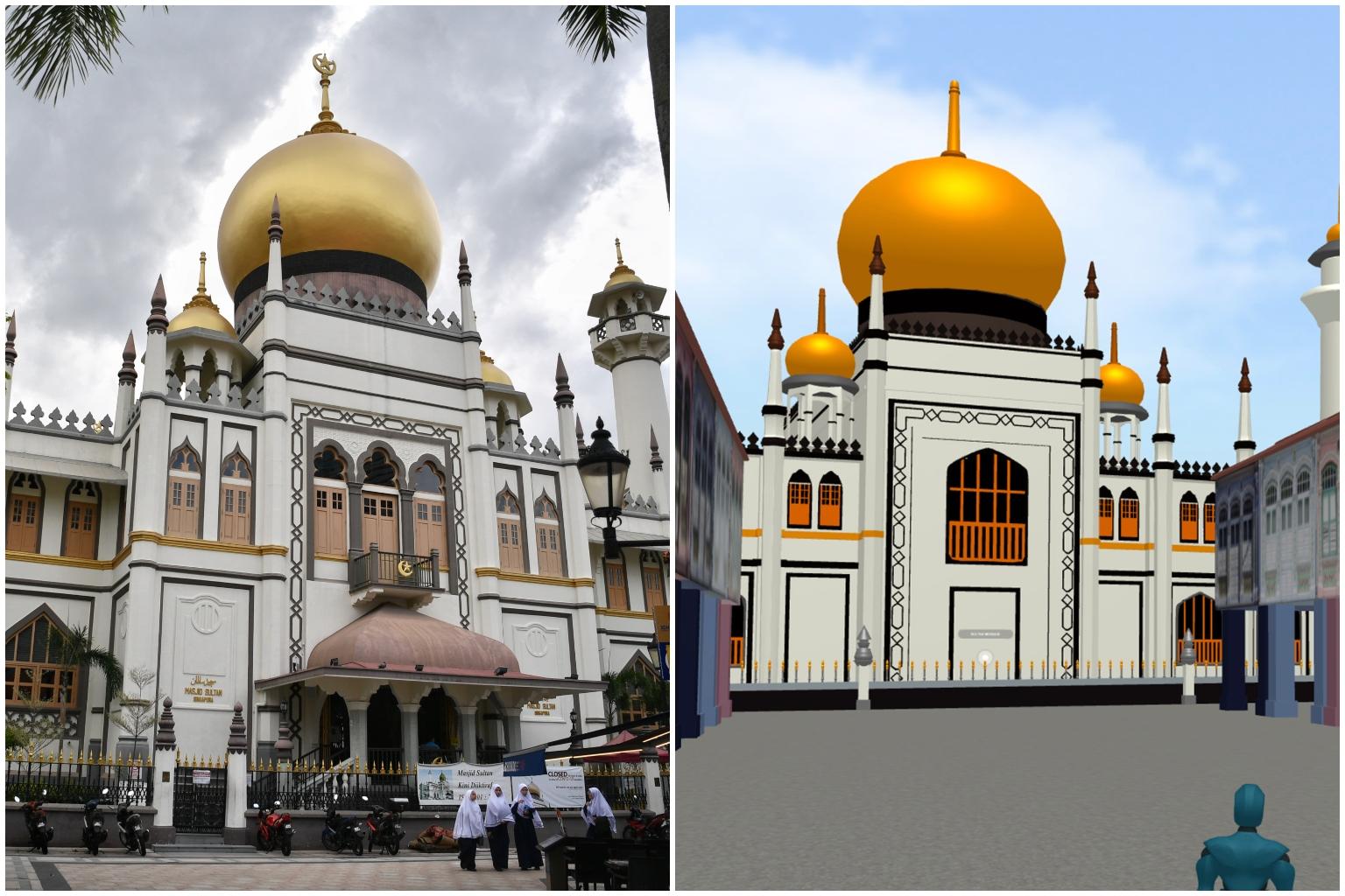
NHB to create 'digital twin' of Kampong Glam, invites artists and creators to contribute
Sign up now: Get ST's newsletters delivered to your inbox

This is the first time NHB is producing a 3D virtual replica of a heritage precinct.
PHOTOS: ARIFFIN JAMAR, NHB AND REVEZ
Follow topic:
SINGAPORE - The National Heritage Board (NHB) is developing a "digital twin" of Kampong Glam (which used to be known as Kampong Gelam) that people can visit virtually, and is calling for creatives to contribute to this endeavour.
The effort - the first time NHB is producing a 3D virtual replica of a heritage precinct - aims to bridge online and offline experiences and encourage users to visit Kampong Glam both physically and virtually.
When the virtual project is ready at the end of the year, visitors to the virtual Kampong Glam will be able to navigate 3D virtual scenes and tours to learn more about the area's history and vibrant culture.
NHB is inviting local artists and creators to be part of the process of developing this project.
From now till Aug 31, the board is accepting digital project proposals under its annual DigiMuse Presents initiative.
The initiative aims to reach out to the wider technology sector to crowdsource ideas and build vibrancy in the cultural sector.
Mr Jervais Choo, programme director of DigiMuse Presents, told The Straits Times on Thursday (Aug 12): "Think of the virtual worlds created in games such as The Sims. Ours is a virtual counterpart of the actual precinct, with 3D model replicas and interactivity such as spaces to explore and games to play, to enrich and enliven our experience of Kampong Glam."
He said users will be able to navigate their avatars and even potentially experience live-streamed festivals and events.
"As we aim to bridge online and offline experiences, we are keen to explore the possibilities of immersion, and blending digital and physical experiences," said Mr Choo.
Interested artists and creators may submit proposals that will contribute to the virtual precinct by e-mailing DigiMuse@nhb.gov.sg by 4pm on Aug 31.
Each selected project may receive up to $25,000 in funding and be showcased on NHB's platforms later this year.
Submissions will be reviewed by a panel of representatives from NHB, and the results will be announced in October.
The board added that the proposals can take inspiration from landmarks in the area like the Malay Heritage Centre, and tap the centre's exhibitions, history and collections.
Other resources that participants can reference include the precinct's Street Corner Heritage Galleries, which showcase longstanding businesses, and cultural content found on NHB's heritage portal.
Those keen to find out more about the Kampong Glam project may do so at this website.
Similar projects
Besides offering virtual tours, digital twins of infrastructure also provide government agencies and firms with a safe platform to test new solutions. Here are some examples of how digital twins have been used.

PHOTOS: SINGAPORE LAND AUTHORITY, JTC CORPORATION, NATIONAL PARKS BOARD
OneMap3D Beta
Last September, the Singapore Land Authority (SLA) launched OneMap3D Beta (above), an open-source three-dimensional map portal for businesses, developers and members of the public.
The map provides an immersive view of a user's surroundings and serves as a dynamic visualisation platform.
The SLA said the map will help businesses develop solutions using 3D geospatial data.
Garuda Robotics, for instance, has leveraged this to trial drone delivery of automated external defibrillators to cardiac arrest victims within Singapore's complex urban environment.

PHOTOS: SINGAPORE LAND AUTHORITY, JTC CORPORATION, NATIONAL PARKS BOARD
Open Digital Platform for Punggol Digital District
JTC Corporation, the Government Technology Agency and ST Engineering are jointly developing an Open Digital Platform for Punggol Digital District.
The platform will serve as the "digital backbone" of the district, allowing building management processes and resources to be optimised. It also utilises digital twin technology (above) to run simulations in a virtual operating environment so that companies can access live data and develop solutions in a safe way.
For example, driverless cars can be tested and programmed through the simulations without the need to send a real car onto the streets.

PHOTOS: SINGAPORE LAND AUTHORITY, JTC CORPORATION, NATIONAL PARKS BOARD
Remote Tree Measurement System
The National Parks Board has been trialling light detection and ranging (Lidar) technology in its tree inspection regime in various ways since 2019.
Remote Tree Measurement System software is used to interpret data from Lidar scans of trees.
For instance, 3D models (above) of individual trees can be tested in simulations of wind speeds of up to 80kmh to mimic thunderstorms - as opposed to wind speeds of 5kmh to 10kmh that trees here are typically exposed to - so that arborists can determine if the tree structure can hold up against harsh weather.

