Haze season for 2019 could ease as early as next week: Asean weather watchdog
Sign up now: Get ST's newsletters delivered to your inbox

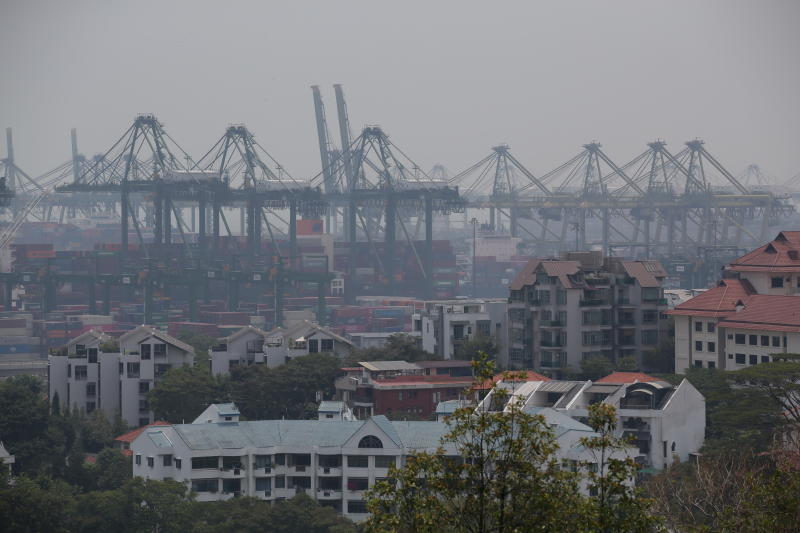
View of PSA Pasir Panjang Terminal at around 1.45pm on Sept 26, 2019. The 24-hour PSI reading in the southern part of Singapore was 66 as at 1pm on Sept 26, 2019.
ST PHOTO: KEVIN LIM
SINGAPORE - The haze choking the region is set to ease next week, with fire-dousing rains heralding the end of the dry season.
The Asean Specialised Meteorological Centre (ASMC), which has been monitoring and assessing the region's haze for more than two decades, told The Straits Times that its data shows that the current south-west monsoon season is transitioning into the inter-monsoon season - which brings more rainfall over Singapore and the region.
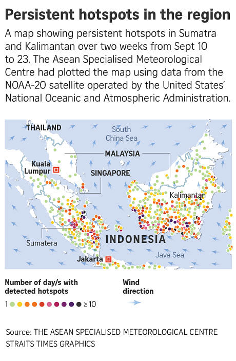
"While hot spot activities could still persist in Sumatra and Kalimantan, the haze situation is forecast to improve in the southern Asean region with increased rainfall during the inter-monsoon period," said a spokesman for the centre.
After years of relatively clear skies, Singapore was plagued once again by the scourge of haze this year. While it was not as bad as the choking pollution that blanketed the region in 2015, the haze caused unhealthy air quality in Singapore over the past few weeks. In Indonesia and Malaysia, where the situation was far worse, schools were closed and flights grounded.
The ASMC was established in 1993 by member states and is headquartered in Singapore.
It is the region's epicentre of haze surveillance and gives early warning of the haze situation in the region, so affected countries can make preparations early.
Using a variety of data sources including satellite imagery and computer models, it supports national meteorological centres in the region in weather and climate prediction, monitoring and assessment of land and forest fires, and the occurrence of transboundary smoke haze for South-east Asia.
During the south-west monsoon, which Singapore is currently experiencing, prevailing winds typically blow from the south-east or south for Singapore, and rainfall is generally sporadic.
But as the country transitions into the inter-monsoon season, which the ASMC expects will start early next week, more rain is expected. Winds during this season are expected to be light and variable in direction.
The effect of the cooling of the eastern Indian Ocean - which suppresses the formation of rainclouds over the region - is also expected to ease over the rest of the year, bringing more rain.
Monsoon
While many may often associate the term "monsoon" with more rain, this is not the case.
An example would be the current south-west monsoon season, which has brought drier weather over the region, said weather scientist Koh Tieh Yong from the Singapore University of Social Sciences.
This is because the word monsoon - which has roots in the Arabic word mausim, meaning seasons - is actually more closely tied to changing wind directions, said Associate Professor Koh.
Singapore experiences two distinct monsoon seasons - the south-west monsoon season, which typically stretches from June to September, and the north-east monsoon season, which lasts from late November to early March.
Their names come from the directions the winds blow from. During the south-west monsoon season, winds are predominantly from the south, while the opposite is true for the north-east monsoon season.
The south-west monsoon season coincides with the northern hemisphere summer. Because of various factors, including the heating of the Asian continent in the north, the rainband over the equator shifts over the northern Asean region. This makes the weather drier over the southern Asean region, explained Prof Koh.
The reverse happens during the north-east monsoon season, when the southern hemisphere experiences summer.
This shifts the rainband south, over Singapore, bringing heavier rain from November to January.
"But by February, the rainband has passed by us moving southwards to Indonesia, making it the driest month in Singapore. So the north-east monsoon season is at first wet and then dry, in Singapore," said Prof Koh.
But the change between monsoon seasons do not happen overnight, he added. It is gradual, which is why Singapore also experiences two inter-monsoon seasons in a year.
During an inter-monsoon season, northerly and southerly winds are engaged in a "tug-of-war" with one or the other sometimes winning, said Prof Koh.
"As we are experiencing the tail-end of the south-west monsoon season now, winds from the south and south-east may still prevail, although they are gradually weakening. At the same time, winds from the north-east are also strengthening, and we can expect to see this tug-of-war for one to two months before north-easterly winds prevail," he said.

Haze monitoring
Mr Masagos Zulkifli, Singapore's Minister for the Environment and Water Resources, said in a Facebook post on Thursday evening (Sept 26) that the centre has been providing technical assessments and updates on the situation with its meteorological forecasts and data on hot spot activities.
He said: "This will help with operational efforts to address the haze. More importantly, it has always given advance notice of intense or prolonged dry weather that can trigger forest fires in Asean. It has done so diligently all these years."
ASMC told The Straits Times that it provides early warning of transboundary haze for member countries through tiered warnings.
It had raised the "Level 1" alert for southern Asean countries on July 2 this year advising affected nations - including Singapore and Indonesia - on the onset of the season .
A "Level 2" alert was flagged for the same region on Aug 1, when the hot spot count in Sumatra and Kalimantan started going up.
In general, such alerts are given when ASMC detects more than 150 hot spots with dense smoke plumes in two consecutive days, amid persistent dry weather with winds blowing towards Asean countries. However, other variables, such as weather conditions, are also taken into consideration, and this may result in this alert level being raised even if the hot spot threshold is not met.
"Level 3" alerts were raised for Kalimantan on Sept 5, and Sumatra on Sept 9, due to the increased risk of transboundary haze occurrence arising from escalating hot spot situation and deterioration in haze conditions, said an ASMC spokesman.
Similar to level 2 alerts, level 3 warnings - the highest level - are generally issued when more than 250 hot spots with dense smoke plumes are detected in two consecutive days, amid dry weather and with winds blowing towards Asean countries, ASMC said. But weather factors are also considered before this is raised.
A variety of data sources are used for such forecasts and warnings, said the centre spokesman.
Hot spot data, for example, is processed from satellites operated by various agencies, including the United States National Oceanic and Atmospheric Administration (NOAA), the National Aeronautics and Space Administration (Nasa), and the Himawari-8 satellite operated by the Japan Meteorological Agency.
Data from the Himawari-8 satellite is available every 10 minutes. Polar orbiting satellites such as the NOAA20 satellite operated by NOAA also allows ASMC to detect hot spots both in the day and night.
This is also supplemented with ground observation reports from the various national meteorological centres and air quality data.


