Thailand prepares evacuation in northern provinces as Mekong water level rises
Sign up now: Get insights on Asia's fast-moving developments

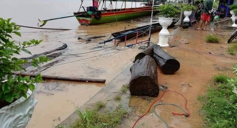
In north-eastern province of Ubon Ratchathani, flash floods submerged several communities along its banks.
PHOTO: THE NATION/ASIA NEWS NETWORK
Follow topic:
BANGKOK (XINHUA) - The Thai government has instructed the governors of all northern provinces to prepare to evacuate residents as water level in the Mekong River continues to rise.
Before noon on Tuesday (July 31), the Mekong River has burst its banks, allowing water to flow into riverside areas of Mukdahan Province.
Mukdahan Governor Paithoon Rakprathet said the water level at the Mukdahan hydrographic centre was measured at 12.54 metres, four centimetres higher than the designated "maximum level" of 12.50 metres.
At the Indochina Market, hundreds of shops moved their goods to higher grounds.
"Aside from the monsoon floods, water discharged from Nam Ngum 5 Dam in Laos into Nong Khai Province has also increased the water mass in the river," said Paithoon, "and because of this, we had to declare the districts of Muang and Dong Luang as flood disaster zones."
Col Boonsin Padklang, commander of the military peace-keeping force in Mukdahan, has deployed soldiers to help flood victims.
Military trucks have been sent to flood stricken areas to transport residents out and into higher grounds.
Meanwhile the Disaster Prevention and Mitigation Department on Tuesday announced warnings that 20 northern provinces are at risk of a flood disaster due to high cumulative rainfall.
Chiang Rai and the six north-eastern provinces of Mukdahan, Nakhon Phanom, Sakon Nakhon, Yasothon, Roi Et and Ubon Ratchathani were especially prone to flash floods as a result of continuous heavy rainfall in northern and central Laos.
On Monday night, flash floods in Chiang Rai's northernmost district of Maesai displaced 500 households, according to the Disaster Prevention and Mitigation Department.
Last Saturday, a mudslide in another northern province killed a family of eight and forced more than 200 residents into temporary shelters.
In north-eastern province of Ubon Ratchathani, flash floods submerged several communities along its banks.
Officials said the water level has risen an average of 40 to 50 cm per day.
On Monday, an officer from the national power utility said the Vajiralongkorn Dam in Kanchanaburi province was at 78 per cent capacity, its highest level in 34 years.
Thailand's national weather agency said that about 70 per cent of the north and north-east will see thunderstorms for the rest of the week while less rain is forecast for the rest of the country through Saturday.
Flooding usually peaks around October.
The last mega flood in Bangkok was at 2011, causing billions of baht in damage.

