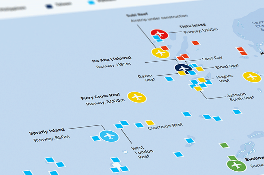
Graphic: Troubled waters in South China Sea

The South China Sea, dotted with small islands, reefs and shoals, is one of the most hotly contested areas in the world.

While unexplored, much of the disputed area around the Spratly Islands and Paracel Islands is believed to be potentially rich in oil and other natural resources.

The sea is also a major shipping route through which over US$5 trillion (S$7 trillion) of maritime trade passes each year.

Who claims what, on what basis?

iFrameResize()

Most of the countries claim based on the exclusive economic zones (EEZ) concept, which gives coastal nations sovereign rights to exploit resources in a 200-nautical-mile (370km) zone from their shore. The EEZ is defined under the United Nations Convention on the Law of the Sea introduced in 1994. This treaty is ratified by 147 nations, including China.

Other nations have right of navigation and overflight in the EEZ. The US has said that its recent military patrols are aimed at protecting the freedom of navigation.

China uses the nine-dash line, plus equally vague "ancestral rights", to claim almost all of the South China Sea.

In 2013, Manila went to the Permanent Court of Arbitration in The Hague seeking to clarify its economic entitlements under the UN Convention on the Law of the Sea and declare void China’s so-called “nine-dash line” claim on the South China Sea.


The Spratly Islands

iFrameResize()

Made up of over 100 small islands and reefs, the Spratlys is a major flashpoint in the South China Sea. While China is not alone in pursuing reclamation and other construction projects on the contested islands, the speed and scale of its activities have set off alarm bells in the region and worldwide.

Claimants: Besides China, the Spratlys are also claimed by Taiwan and Vietnam, who argue that the islands fall within their respective EEZs. China also claims them based on its controversial "nine-dash line" map. The Philippines, Malaysia and Brunei claim some of the islands, based on the their EEZ. About 45 of the islands are occupied by the armed forces of China, the Philippines, Malaysia, Vietnam and Taiwan.

China has been building airstrips, harbours and military facilities on several of the islands. Observers are closely monitoring in particular the developments on Mischief Reef, Fiery Cross Reef and Subi Reef.

Fiery Cross Reef

iFrameResize()

Located on the on the west side of the Spratly Islands, it is claimed by China, the Philippines and Vietnam. China started building an airstrip in 2014, and the 3,000m runway was completed in September 2015.

In January 2016, it tested the runway for the first time by landing several civilian airliners. The airstrip is capable of handling almost any type of aircraft in China’s inventory, including the Chinese H-6G bomber. The other two being constructed on Mischief Reef and Subi Reef are of similar capabilities, according to analysts.

Fiery Cross reportedly houses a harbour large enough to dock military tankers. It also houses helipads, air defence guns and possibly has a radar tower under construction. The satellite image below, captured in January 2016, shows the infrastructure build-up on the island, including the airstrip.

Experts say Fiery Cross could eventually become a command-in-control centre for the Chinese navy, and may allow China to enforce an Air Defence Identification Zone over the South China Sea. China announced in early June it is building a lighthouse on the Fiery Cross due for completion by end of 2016.

Mischief Reef

iFrameResize()

This reef in Spratly Islands falls within what the Philippines claims to be its 200 nautical mile exclusive economic zone, lying 129 nautical miles from Palawan. China has occupied Mischief Reef since 1995 and recent activity hints at the development of a naval base. Frigates and coast guard ships have been spotted in surrounding waters.

China is building its third airstrip in the Spratlys here, after Subi Reef, according to the CSIS Asia Maritime Transparency Initiative. A 60m lighthouse under construction on the east end will be the tallest of all the structures on the Spratlys when it is completed at the end of 2016, reported Xinhua. The following satellite image captured in January 2016, shows the airstrip among other facilities.

Subi Reef

iFrameResize()

Subi was submerged at high tide before China turned it into an island. The following satellite image taken in January 2016 shows an airstrip, and on-going dredging activities. A lighthouse began operations in April. There are two other lighthouses in operation on Johnson South and Cuarteron reefs.


The Paracels

iFrameResize()

The Paracels have been under Chinese control for decades but the island is also claimed by Vietnam and Taiwan. It is made up of some 130 small coral islands and reefs.

Claimants: China and Taiwan claim artifacts show ancient contacts with the islands while Vietnam's claim is based on EEZ. Currently, the islands are occupied by China.

Woody Island

iFrameResize()

The site of the largest Chinese presence on the Paracels. China has deployed surface-to-air missiles, and built facilities such as harbours and buildings , including a primary school.


Scarborough Shoal

Four construction workers fell from a temporary working platform below the Yio Chu Kang flyover yesterday.

Philippines and China lay claim to the shoal, with China having effective control. In the satellite image below, white specks can be seen around the island which appear to be boats.

Sources: AFP, Reuters, Globalsecurity.org, CIA World Factbook, BBC, CSIS Asia Maritime Transparency Initiative / DigitalGlobe​
Straits Times Graphics

Join ST's Telegram channel and get the latest breaking news delivered to you.