Singapore government agencies turning to 3D indoor mapping
Maps can be useful for public security, urban warfare scenarios and heritage preservation
Sign up now: Get ST's newsletters delivered to your inbox

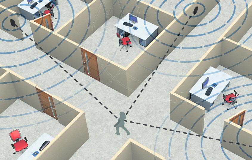
Indoor positioning: Devices such as smartphones can be con figured to detect signals from Wi-Fi, Bluetooth or ultra-wideband transmitters located around the building.
PHOTO: ST GRAPHICS
Researchers and government agencies across Singapore are beginning to embrace three-dimensional computer mapping of indoor spaces - a trend that could enhance public security for emergency situations, among other benefits.
The 3D maps, which detail interior spaces and are constructed with the help of lasers, could help simulate and manage crowds, such as when an evacuation has to be carried out after a fire or terror attack.
For a start, researchers at the Agency for Science, Technology and Research used computer models to study crowd movements at an exhibition at the Suntec Singapore Convention and Exhibition Centre earlier this year.
Such maps could also be useful for the military in tackling urban warfare scenarios.
Said Mr George Loh, director of programmes at the National Research Foundation (NRF): "We are talking to different agencies to see their needs so that we can prioritise some of the spaces to be modelled."
Potential candidates include MRT stations, schools and community centres. In June, the Singapore Land Authority created high-resolution 3D maps of Marina South Pier MRT station.
This comes even as Singapore last month launched SGSecure, a nationwide movement that aims to increase the public's preparedness and resilience in emergency situations such as a terrorist attack.
Besides helping with evacuating large crowds in an emergency, 3D indoor mapping and data analysis could streamline building maintenance and heritage preservation.
For instance, the Singapore Land Authority created a 3D map of a historic black-and-white bungalow on Goodwood Hill in August.
Another use of 3D indoor maps involves combining them with indoor positioning technology to track people's locations and movements. The technology uses radio transmitters such as Wi-Fi and Bluetooth to triangulate the person's position with a smart device that detects those radio signals. The Government Technology Agency's Geospatial Specialist Office is working on improving the accuracy from metres to centimetres.
The NRF's Mr Loh said this kind of data, which is kept anonymous to protect people's privacy, could also help shopping malls understand customer preferences and improve the navigability of their premises.
Mr Thomas Pramotedham, chief executive of geographic information systems provider Esri Singapore, said the real power of 3D mapping goes beyond visualisation. It lies in an ability to put many different types of information together, analyse the data and generate solutions to problems.
Mr Pramotedham said Singapore is not only a "thought leader" in such technology but also turning ideas into reality, and that many other cities are learning from the Republic. "People are thinking about mapping out a 3D city but we're actually doing it."


