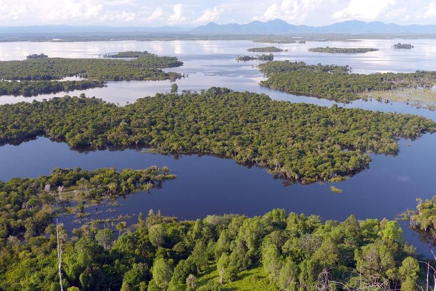
SINGAPORE – With their swelling bellies of carbon, the tropical peatlands of South-east Asia are considered one of humanity’s key allies against climate change.
But a new study has found that even the canals that are carved into the landscape to drain these swamp forests for agriculture play a big role in “unleashing” carbon into the atmosphere.
Peatlands are some of the largest stores of carbon in the world, said study co-author Lihini Aluwihare, a chemical oceanographer at the Scripps Institution of Oceanography at the University of California San Diego.
Peat, or partially decomposed plant matter, accumulates in waterlogged environments such as in tropical forests where there are high levels of rainfall or in mangrove swamps, as water slows down the decay process that requires oxygen.
Peatlands form over hundreds and often thousands of years as organic matter accumulates in waterlogged soils, swelling into vast domes that can be up to 20m deep.
These deposits lock up carbon dioxide that would otherwise be released into the atmosphere if the dead vegetation were to fully decompose.
“Reintroducing any of that carbon into the atmosphere is of major concern when it comes to climate change. That’s why it’s so important that we figure out what controls the release of carbon from disturbed peatlands,” Professor Aluwihare said.
Draining peatlands of water exposes their accumulated dead plant material to oxygen, causing it to decompose and release carbon dioxide.
But the new study, published on March 8 in the journal Nature Geoscience, had found that the canals used to drain peatlands in South-east Asia are likely also hot spots for greenhouse gas emissions.
Prof Aluwihare said: “Canal systems are likely a significant source of carbon dioxide emissions on top of the emissions from dried out peat soils, and we are probably underestimating the climate impacts of degrading these systems.”
The researchers collected water samples from peatland canals in West Kalimantan, Indonesia, in 2022 and measured how quickly the organic matter in vials of peatland canal water is broken down by microbes and by sunlight, as well as how much carbon dioxide is produced in the process.
They found that about 35 per cent of the microscopic organic matter dissolved in the water gets broken down a day, which equates to an average of 70mg of carbon dioxide released per sq m of canal surface a day.
Sunnier days, higher oxygen concentrations in the canal water and higher mixing of the canal waters were shown to up the rate of carbon dioxide emissions.
South-east Asia is home to more than half of the world’s peatlands, the vast majority of which are swamp forests in Indonesia.
Tropical peat soils store up to 20 times more carbon as tropical rainforests on other types of mineral soils, according to think-tank World Resources Institute.
Although peatlands cover just 3 per cent of earth’s land surface, they store twice as much carbon as all the world’s forests combined, as reported by the United Nations.
This is because the slow rate of decomposition of water-covered plant matter means more carbon is retained in the soil as peat than is released into the atmosphere. This is considered an overall net removal of carbon from the atmosphere.
But peatlands are being lost rapidly, with the institute estimating that around 25 million ha of tropical peatlands in the region have been deforested and drained over the past three decades.
Stanford University postdoctoral scholar and first author of the study Jennifer Bowen said their findings will help predict which canals promote higher emissions and which peatland areas would benefit from restoration projects.
For example, re-vegetating peatlands that were deforested could shade canals, limiting the carbon produced due to exposure to sunlight.
Now, a team from the Singapore-MIT Alliance for Research and Technology (Smart) and Nanyang Technological University (NTU) has developed a method to measure the amount of carbon stored in peatlands by mapping out their shapes using elevation data from satellites.
This could give policymakers a better idea of how much carbon emissions could be released from draining peatlands for agricultural or urban uses.
Such information can help make a stronger case for the conservation of these carbon-rich ecosystems anywhere in the world, even areas in remote parts of the Amazon Basin, New Guinea and the Congo Basin.
Dr Alex Cobb, senior principal research scientist at Smart and the study’s first author, said current efforts to restore peatlands involve the blocking of drainage canals to re-wet the peatlands.
But re-wetting without an accurate understanding of the topography of a peatland can lead to unsuccessful re-wetting or even floods, he said.
The new method can help conservationists or governments determine the areas most optimal for building dams, or the areas in which wetland plants can be replanted. The method will also help them predict flood-prone areas during peatland re-wetting.
Study co-author Rene Dommain, a senior research fellow at NTU’s Earth Observatory of Singapore, said the new method will help countries with large peatland areas in reporting and protecting their carbon stock.
“We can also determine peatland areas at risk of fire due to changes to their morphology from artificial drainage, and contribute towards alleviating the recurring threats of haze that plague Singapore and the region.”