

SINGAPORE - In 2016, a Mercedes-Benz barrelled down the Ayer Rajah Expressway (AYE) against the flow of traffic, before crashing into a car and a scooter. One person was killed in the accident and four injured.
At the Mercedes driver's trial in 2019, there was a question about whether the expressway's slope had contributed to the car's speeding as it moved against traffic flow, said Ms Grace Wong, acting deputy laboratory director of Health Sciences Authority's (HSA) Forensic Chemistry and Physics Laboratory.
Technology, in the form of a three-dimensional map of that stretch of the expressway, helped the forensic scientists calculate the gradient of the AYE stretch, without having to manually scan accessible parts of it.
The driver was eventually sentenced to a year's jail.
"The ability for us to go back in time, so to speak, and revisit that scene (digitally) was invaluable," said Ms Wong.
Technology now forms a cornerstone of the work by HSA’s traffic crash reconstruction team, which can conduct more of its investigations remotely.
In the past, a larger number of expressways and roads had to be closed for forensic scientists to manually take 3D laser scans of the crash sites, while investigating complex and fatal traffic accidents.
It was time-consuming and disruptive to the flow of traffic, said Dr Alaric Koh, acting division director of HSA’s Forensic Science Division.
Before laser scanners were used, the scientists even had to use measuring rollers and tapes to measure the width and distance of a site.
Dr Koh added that while its traffic crash reconstruction team looks into about 80 cases annually now, compared with up to five a year more than a decade ago, its use of advanced technology has helped the team investigate these accidents more efficiently.
In 2021, there were 100 fatal road accidents.
These technologies include three-dimensional replicas of the accident site and simulation models that recreate events leading up to the accident and its aftermath.
Recreating the accident helps forensic scientists answer investigative questions, such as whether the vehicles were speeding or flouting traffic rules.
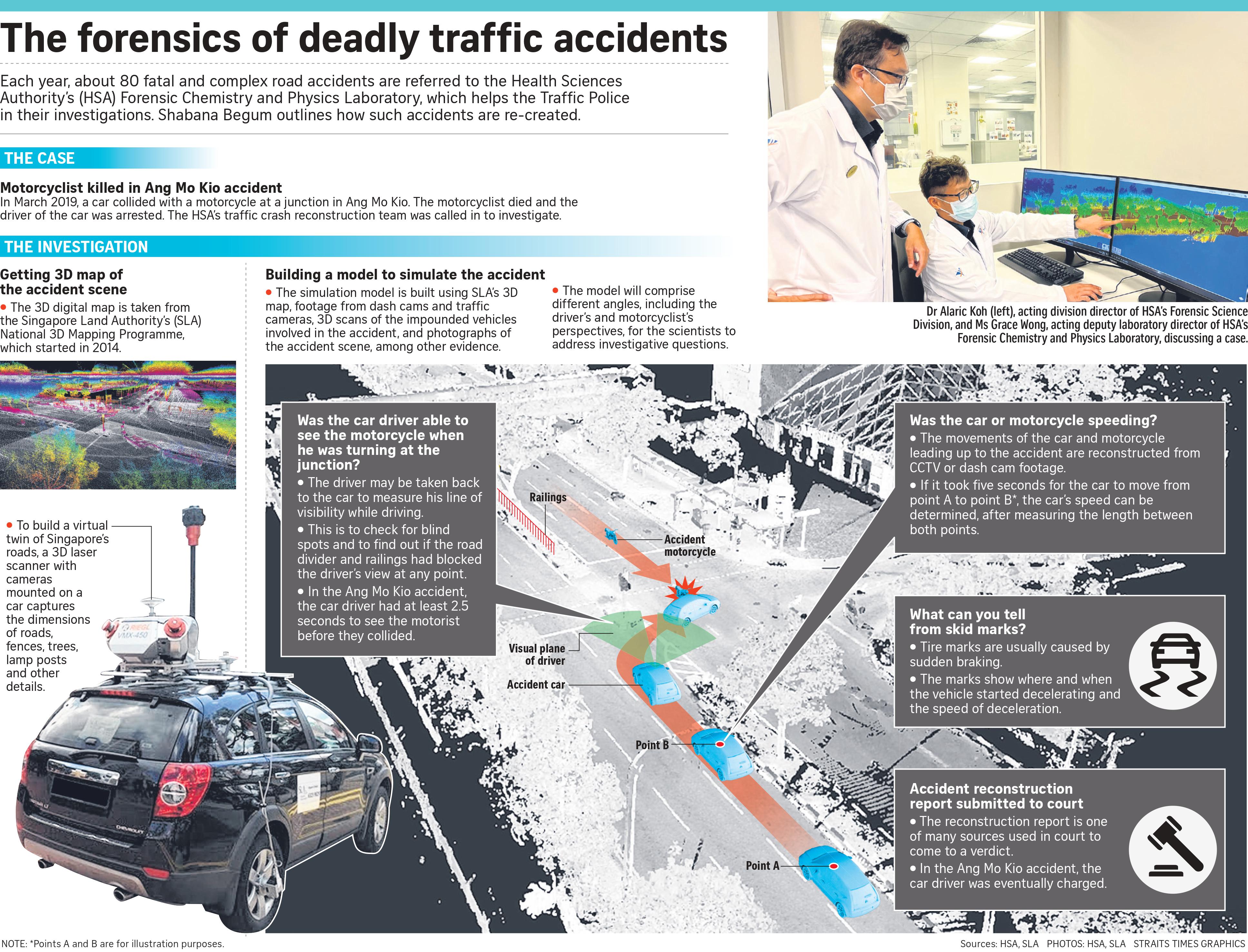
The HSA team can use digital replicas from the Singapore Land Authority's (SLA) National 3D Mapping Programme, which started in 2014, to measure the length of a stretch to calculate a vehicle's speed. Through the SLA initiative, every road, lane and highway in Singapore was mapped via a 3D laser scanner with cameras mounted on a car.
The scanner sends out millions of laser pulses in a second, and when the pulses hit objects such as a road stretch, trees or lamp posts, these objects' heights and geometry are plotted in a 3D space.
Since 2019, HSA's Forensic Chemistry and Physics Laboratory has used SLA's 3D map for about 50 cases.
While the forensic scientists have to take their own scans at times, mainly because the SLA data is outdated due to factors such as road reconstruction, Dr Victor Khoo, director of SLA’s survey and geomatics division, said the government body will continue to update the map regularly.
"We are going to start another campaign to continue to capture (3D data of the roads). This ought to be a continuous process. And autonomous vehicles will also depend on these 3D point cloud data to drive themselves," he added.