
Relations between Jakarta and Beijing, which are not always smooth sailing, took a new twist last Friday when Indonesia unrolled a map depicting an expansion to its maritime territory with the naming of the waters off its northern perimeter North Natuna Sea.
Although it lies in Indonesia's Exclusive Economic Zone (EEZ), the waters north of the Natuna Islands bordering the South China Sea have no name and are often designated, albeit loosely, as part of the latter.
The move comes as Jakarta continues to woo investors, particularly from China and Japan, to participate in its infrastructure works.
President Joko Widodo has, since his term started in October 2014, looked to infrastructure development to boost South-east Asia's largest economy.
Chinese and Japanese investors have been invited into the energy and transport sectors. The electricity penetration rate is low in Indonesia and logistic costs are among the highest in South-east Asia due to traffic snarls caused by poor access roads. There is also a dearth of good sea ports in Indonesia.
China Railway Corp is building the US$5 billion (S$6.9 billion) Jakarta-Bandung high speed train, while China Power Investment Corp and Anhui Conch Cement are major players in other infrastructure projects.
Also, Jakarta and Beijing in the past few years have been managing tensions over maritime issues off Natuna Islands. Mr Joko has visited the Natunas several times in recent years to underline the country's seriousness in protecting its fishing grounds from poaching.
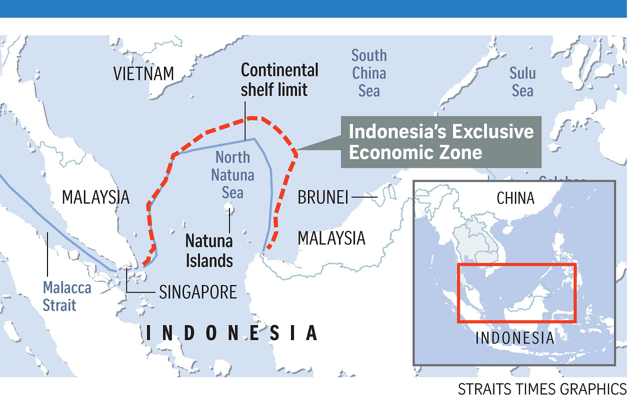
In March last year, Jakarta accused a Chinese coast guard vessel of trying to forcibly prevent the detention of a Chinese fishing boat seized by the Indonesian authorities near the Natunas. Jakarta said the boat was fishing illegally in Indonesian waters. Beijing said the incident took place in China's "traditional fishing grounds". There have been other run-ins.
The new maritime map could change that equation.
"For now, the ball is in China's court. Indonesia has made its position clear on the new map, based on the recently completed delimitation agreements with Singapore and the Philippines as well as, significantly, the July 2016 tribunal ruling," Mr Evan Laksmana, a researcher at Indonesia's Centre for Strategic and International Studies, told The Straits Times.
In July last year, an arbitral tribunal in The Hague handed Manila a sweeping victory in a case it filed challenging Beijing's expansive claims to the South China Sea. The tribunal confirmed the Philippines' jurisdiction over its EEZ.
China boycotted the proceedings and has refused to acknowledge the Philippines' jurisdiction.
Beijing continues to hold on to its U-shaped "nine-dash line" claims that extend from its Hainan island, south to Borneo to pass by north of the Natunas, and north to Taiwan.
University of Indonesia international law expert Hikmahanto Juwana said Jakarta's updated map serves to assert its position that it does not recognise China's nine- dash line claim, which was also not recognised by the Hague's tribunal.
China's Foreign Ministry spokesman Geng Shuang, when asked about the naming of North Natuna Sea on Friday, said: "The so-called change of name makes no sense at all and is not conductive to the effort of the international standardisation of the name of places."
Indonesia's Deputy Coordinating Minister of Maritime Affairs Arif Havas Oegroseno on Friday said Jakarta has been updating its maps for decades.