
Asian Insider
Who was here first? Why maps, old compasses and history classes matter in South China Sea dispute
In the southern Chinese fishing town of Tanmen, a museum shaped like a fishing boat safeguards Han Dynasty records asserting a millennia-old hold over “ancestral seas”.
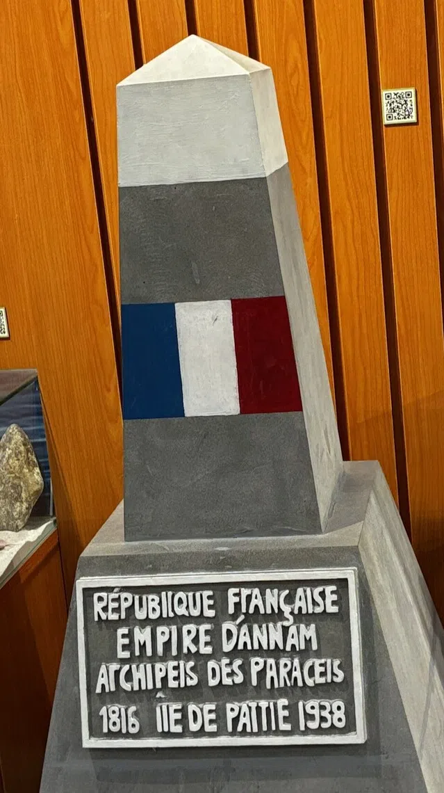
In Da Nang, Vietnam, a scenic coastal highway and a replica of a French colonial marker serve as monuments to the Paracel Islands – territory that then South Vietnam lost to China in a deadly 1974 naval clash.
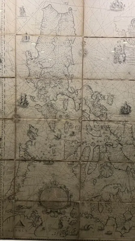
And showcased behind protective glass in Manila’s National Library, the 1734 Murillo Velarde map meticulously details the contested Scarborough Shoal as Philippine territory, centuries before Beijing drew its expansive “nine-dash line”.
TANMEN, China/DA NANG, Vietnam/MANILA – Nearly a decade has passed since The Hague issued its landmark decision in the South China Sea Arbitration, in which it found that China’s claims of historic rights within a vague, U-shaped boundary called the nine-dash line had no legal standing under United Nations conventions. Yet the region is still far from agreement on the matter.
Disruptions to energy supplies and other materials from the closure of the Strait of Hormuz in 2026 are a sharp reminder of the vulnerability of the critical shipping lanes that facilitate global trade. About one-third of global maritime shipping passes through the South China Sea, a vital conduit for Indo-Pacific trade routes.
The front lines of the overlapping and varied claims, meanwhile, have broadened beyond international law and the dispatch of naval destroyers. It is being aggressively fortified by competing historical narratives, disseminated through institutions ranging from state-funded museums to primary school classrooms.
On the ground, these narratives appear to be taking root not just among the local communities, but also at the national level.
The reality is that these questions of historical claims may never be truly settled and the crux may lie in whether claimant states opt to prioritise regional stability over national narratives.
China’s ‘ancestral seas’
For China, issues of sovereignty are deeply rooted in the access to and ownership of resources, which it believes can be traced back more than a millennium.
Tanmen, in China’s southern Hainan province, is known for its prized hauls from the depths of the South China Sea, ranging from grouper to parrotfish to Spanish mackerel.
For generations, Tanmen’s fishermen have made their living in what they commonly refer to as their “ancestral sea”, stretching as far south as the Spratly Islands, hundreds of kilometres away, with voyages that could take more than a month.

A map at the Genglubu Museum in Tanmen showing the connections between different features in the South China Sea, including Huangyan Dao (Scarborough Shoal), Meiji Jiao (Mischief Reef) and Zengmu Ansha (James Shoal).
ST PHOTO: LIM MIN ZHANG
Liu Wei, a 61-year-old Chinese retiree and a history and museum buff, said that the idea of an ancestral sea for local fishermen is both based on fact and has emotional resonance.
“The sea that they fish on is not something they can pass on (as inheritance) – it’s not like there is a title deed, but they have fished there for many generations, so there is this connection formed by history,” said Liu.
Even with a population of just 31,000, Tanmen plays an outsized role in China’s South China Sea claims. In China’s telling, this fishing town, which dates back to the Song Dynasty (AD960 to AD1279), is living proof of the Chinese people’s historical presence in the South China Sea.
Similar claims of continuous occupation and jurisdiction form a cornerstone of its “historic rights” over the sea’s islands and other maritime features.

Tanmen fishermen are known to bring back prized catches from the South China Sea, ranging from grouper to parrotfish to Spanish mackerel.
ST PHOTO: LIM MIN ZHANG

An information board at Tanmen port about the genglubu navigation manuals, which have been passed down by generations of Chinese fishermen.
ST PHOTO: LIM MIN ZHANG
President Xi Jinping visited the town in 2013 – just months after Manila took its case to the Permanent Court of Arbitration – speaking with local fishermen and asking if they had encountered any trouble at sea. It cemented Tanmen’s status as a historic hub and the strategic gateway to the contested waters.
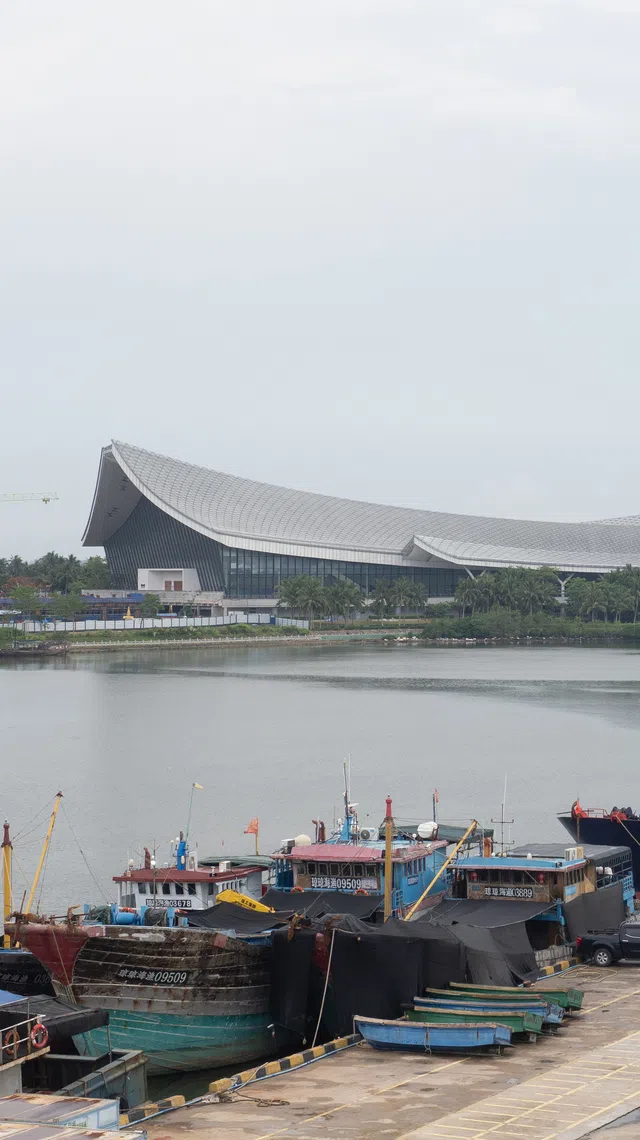
This was solidified by the completion of the national-level China (Hainan) Museum of the South China Sea in Tanmen in 2018. Visually striking with its undulating roofline, it is currently undergoing expansion work that, when completed in 2027, will make it one of the largest museums in the country, spanning the equivalent of about 20 football fields.
The museum presents imperial court records showing that Chinese people had discovered what it today calls the South China Sea islands “no later than the 2nd century BC”, during the Western Han Dynasty.
Another panel shows the results of archaeological excavations on Robert Island in the Paracels, which are claimed by several parties. The evidence of human settlement that was uncovered is described as “one of China’s most important historical testimonials to human activities of the Chinese in the South China Sea”.

Archaeological evidence of human settlements in Xisha Qundao, also known as the Paracel Islands, and shipwreck relics on display at the China (Hainan) Museum of the South China Sea.
ST PHOTO: LIM MIN ZHANG
Manila’s assertive transparency
The geopolitical theatre of the South China Sea has evolved far beyond diplomatic protests and isolated maritime incidents into a sustained, high-stakes grey-zone conflict, neither a state of war nor complete peace.
Breaking sharply from the Beijing-friendly appeasement of his predecessor, Rodrigo Duterte, President Ferdinand Marcos Jr catalysed a profound geopolitical realignment, pivoting Manila back to Washington and its traditional democratic allies after he came to power in 2022.
It included granting US military access to additional bases strategically positioned near potential flashpoints in the South China Sea and Taiwan under the Enhanced Defence Cooperation Agreement. This has bumped up uncomfortably against Beijing’s red lines.
The souring of bilateral ties has also collided with Manila’s tactics of “assertive transparency” – embedding local and international journalists on coast guard and military vessels to broadcast China’s grey-zone tactics in the disputed waters, such as the deployment of water cannon, lasers and tactical ramming.
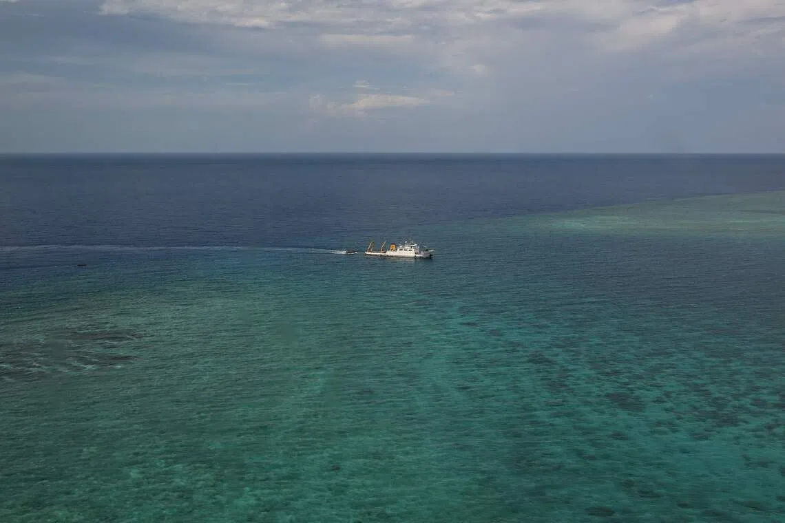
A ship identified by the Philippine Coast Guard as a Chinese research vessel towing a floating structure at the mouth of Scarborough Shoal in the disputed South China Sea on June 15, 2026.
PHOTO: AFP

Philippine authorities sharing information about a floating structure believed to be deployed by China in Scarborough Shoal during a press conference held on June 10, 2026. The structure was removed after the Philippines lodged a diplomatic complaint.
PHOTO: EPA

Philippine Senator Risa Hontiveros raising her country’s flag on Thitu Island in the disputed South China Sea in February 2026. She called for “continuous” pushback against China’s territorial claims in the area.
PHOTO: AFP
This has generated greater international awareness and support, but also increased the political cost of any face-saving diplomatic compromise from both sides.
Volatility is now the main feature of the proxy theatre, marked by multiplying flashpoints and aggressive resupply blockades, including to the BRP Sierra Madre, a rusting, grounded World War II-era ship serving as a fragile sovereign outpost around the Second Thomas Shoal.
The hostilities escalated on June 11 when the Chinese government banned Philippine Defence Secretary Gilberto Teodoro Jr, one of the country’s most vocal critics of Chinese maritime incursions, from entering mainland China, Hong Kong and Macau, along with his immediate family.
Filipino distrust of China has hardened into broad public support for Manila’s assertiveness. A June 2026 survey by local pollster Pulse Asia Research found that 86 per cent of Filipinos agree the government should defend its claims in the South China Sea with like-minded nations in accordance with the arbitral award.
Hanoi’s geopolitical tightrope
In contrast, Vietnam is pursuing a strategy defined by quiet diplomacy, keeping maritime friction out of the headlines while Communist Party chief To Lam rolls out his ambitious agenda for domestic growth and reform, which necessitates deeper economic integration with China.
In April, Lam made a state visit to China days after he was elected president, consolidating his authority in a way some observers compared with Xi’s dual role as party and state leader.
He signed 32 cooperation agreements, including on railway connectivity and financing, and on artificial intelligence and digital infrastructure.

Vietnamese President To Lam (right), accompanied by his Chinese counterpart Xi Jinping, inspecting honour guards at the Great Hall of the People in Beijing in April 2026.
PHOTO: AFP
“Vietnam typically pursues its interests through behind-the-scenes diplomacy rather than open confrontation,” said South China Sea researcher Dinh Kim Phuc, who teaches at the Open University of Ho Chi Minh City.
He added that Vietnam often chooses to keep incidents and tensions at sea with China out of the headlines to prevent a public outcry that could push it towards an escalation that would be difficult to resolve.
One of the main reasons, he said, is that “Vietnam’s economy is deeply integrated with, and even dependent on, China, making it vulnerable to economic coercion”.
Having suffered loss of life during two naval battles with China in 1974 and 1988, Hanoi is also wary of potential armed conflicts.
Behind its diplomatic approach, however, it has actively expanded its physical footprint in the Spratly Islands while continuing to advance historical and administrative claims that directly challenge China’s narrative.
Vietnam claims ownership of a number of rocks and reefs and the adjacent waters, which it defends not through international tribunals or news headlines but by matching China at its own game and altering the reality on the ground.

Satellite images of South Reef taken in 2019 (left) and 2023. Vietnam occupied the reef in the disputed Spratly Islands in 1988, but started building on it only in late 2023.
PHOTO: PLANET LABS PBC
By building up tiny, submerged reefs into fortified logistical hubs – including with expanded runways, deep-water harbours and advanced defence installations – Hanoi is establishing a deterrent and “anti-access” perimeter across its occupied features.
The Washington-based Asia Maritime Transparency Initiative said that in recent years, Vietnam has reclaimed land at eight of the 10 rocks it occupies and built out many of its smaller outposts on submerged reefs and banks. It reported that over the past year alone, Hanoi has reclaimed an additional 2.16 sq km of artificial land across the archipelago, bringing the total reclaimed area to approximately 11.2 sq km.
“Vietnam occupies more features in the Spratly Islands than any other claimant,” Phuc said. “Vietnam’s strategy revolves around fortifying these outposts and integrating them into the domestic administrative structure.”
China, meanwhile, began a major new reclamation campaign at Antelope Reef in the Paracels – some 300km from Hainan and 400km from Da Nang – in late 2025, the first large-scale island-building project Beijing has undertaken in the South China Sea since 2017. This has prompted diplomatic protests from Hanoi.
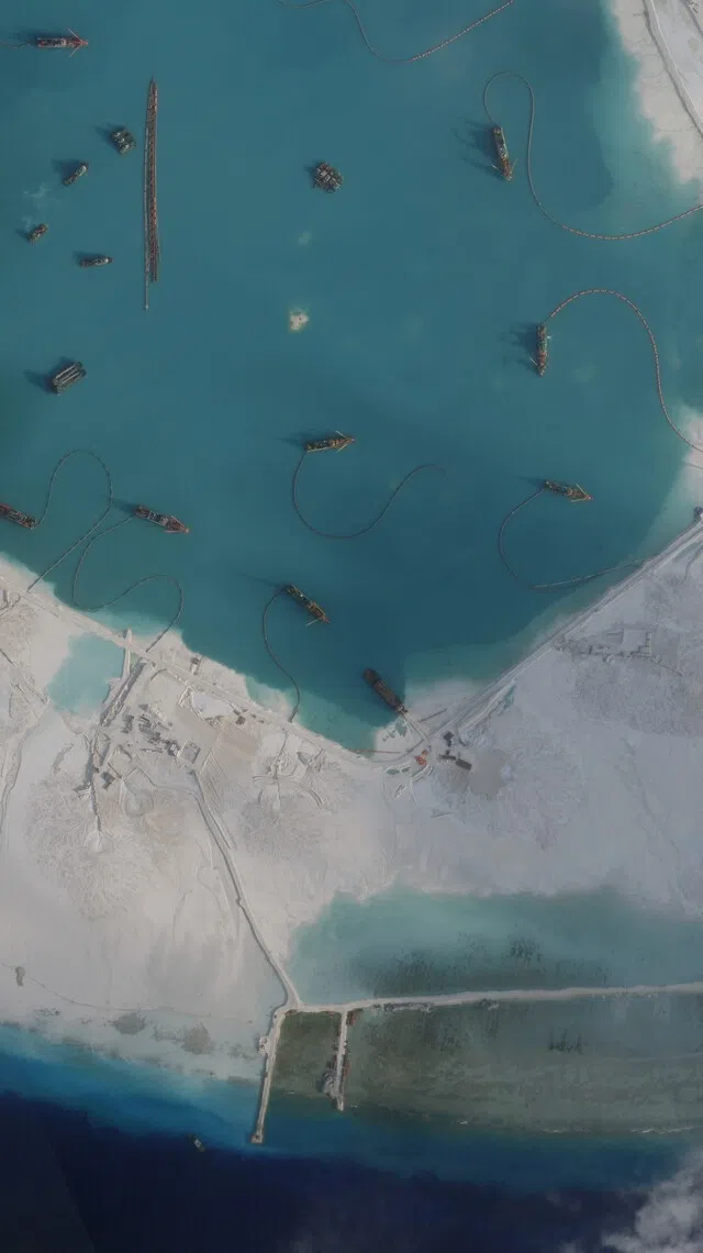
Satellite imagery shows that extensive dredging and landfill operations have created about 6 sq km of new land, making Antelope Reef potentially the largest artificial island in the entire South China Sea.
PHOTO: PLANET LABS PBC
Lost islands
One of the most scenic highways through the fast-growing central coastal city of Da Nang is called Hoang Sa, the Vietnamese name for the Paracels. The nearly 16km drive traces the Son Tra Peninsula along the coast past the giant Linh Ung Pagoda, overlooking the beaches and fishing fleets on the East Sea – the Vietnamese name for the South China Sea.
On Jan 19, 1974, the navy of the then Republic of Vietnam clashed with the Chinese navy in a fierce battle in the Paracels, resulting in the deaths of 74 Vietnamese soldiers and the Chinese takeover of the archipelago.
In 2010, the Da Nang authorities decided to name this newly developed road after the disputed archipelago, which the Vietnamese believe they owned but lost to China half a century ago.
Since the early 2010s, Beijing has carried out extensive land reclamation and infrastructure development, transforming the remote island chain into a militarised logistics hub with airfields and deep-water ports.
Vietnam, however, has never ceded its claim to the Paracels. The islands were declared in 1997 to be an outlying part of Da Nang, administered symbolically by a People’s Committee despite their having no resident population.
“Invasion by force does not create legitimate sovereignty,” says a sign displayed at Da Nang’s Hoang Sa Exhibition Hall, established in 2018.

A sign outside the Hoang Sa Exhibition Hall in central Da Nang proudly claiming that “Hoang Sa (Paracel Islands) is Vietnam’s territory”.
ST PHOTO: NGA PHAM

Displayed inside the exhibition hall are artefacts and historical documents showing Vietnam’s control over the Paracel Islands.
ST PHOTO: NGA PHAM
Historians say the exhibition hall offers documentary evidence dating back to ancient times that the Vietnamese asserted their sovereignty over the Paracel Islands.
“The archipelago was present in many Vietnamese maps and bibliographies from the 15th to the 19th centuries,” said historian Tran Duc Anh Son. “The Nguyen lords (who ruled the southern part of the country, then called Dai Viet) had already set up a Hoang Sa maritime militia team in the 17th century to exploit resources, survey the islands and erect sovereignty markers there.
“Subsequently, in the 19th century, King Minh Mang (of the Nguyen Dynasty) ordered further infrastructure development in Hoang Sa and the militia team was given responsibility for collecting taxes from islanders, as well as patrolling and protecting the islands.”
These activities continued into the French colonial period, when France formally claimed the Paracels and the Spratlys as part of French Indochina. The French government deployed security units and built lighthouses, radio stations and meteorological and hydrological stations on both archipelagos.

A 1944 maritime map of French Indochina – today’s Vietnam, Laos and Cambodia – includes the Paracel and Spratly islands within its boundaries.
ST PHOTO: NGA PHAM
At the centre of the exhibition hall stands a replica of a French-built sovereignty marker bearing the inscription “French Republic, Kingdom of Annam, Paracel Islands 1816 – Pattle Island 1938”.
It serves as a reminder of the lost territory that “nobody should ever forget”, said Huynh Thi Kim Lap, a museum guide and government official.
The Battle of the Paracels, like some other dark episodes in Vietnam-China relations, is not featured in official school textbooks, but educators find ways to fill in the gaps.
“All schools in Da Nang incorporate visits to our museum into their extracurricular activities,” Lap told The Straits Times. Many travel agents also include the Hoang Sa Exhibition Hall in their city tours.
Pham Thi Huong Diu, 32, an office worker in Gia Lai province, brought her six-year-old daughter, Minh Khue, here because she believed the girl “needed to learn about our history”.
“She loves it here and she has so many questions, so we’ll come back,” Diu said.

Office worker Pham Thi Huong Diu and her six-year-old daughter looking at exhibits in the Paracels Museum in central Da Nang.
ST PHOTO: NGA PHAM
Cartographic record
Behind glass at the National Library of the Philippines in the capital Manila, the 1734 Carta Hydrographica y Chorographica de las Yslas Filipinas – also known as the Murillo Velarde map – depicts the Philippine archipelago in meticulous detail: its coastlines, islands and, off the western coast of Luzon, a shoal marked “Panacot”, meaning threat or danger, the local name for what is now Scarborough Shoal.
Farther south, off Palawan’s coast, it shows Los Bajos de Paragua – the shoals of Palawan – which the Philippines today claims as the Kalayaan Island Group and which are known internationally as part of the Spratlys.
“No other country has a map like this showing that Scarborough Shoal and the Spratlys belong to them – not China, not Vietnam, not Malaysia,” says former Supreme Court senior associate justice Antonio Carpio, one of the Philippines’ most prominent advocates for its claims in the West Philippine Sea, the government’s term for its exclusive economic zone and extended continental shelf in the South China Sea.

Former Supreme Court senior associate justice Antonio Carpio, a prominent advocate for the Philippines’ claims in the South China Sea, standing next to the 1734 Murillo Velarde map displayed at the National Library of the Philippines.
ST PHOTO: MARA CEPEDA
Despite this cartographic record, Manila has chosen not to base its case solely on historical maps. The 2016 arbitral ruling, which invalidated China’s expansive nine-dash line and affirmed Philippine rights under the United Nations Convention on the Law of the Sea (UNCLOS), offers what Manila considers a clearer legal foundation.
Carpio spent years tracking down the original copies of these maps, funding purchases and acquisitions on his own and through collectors abroad to ensure they were preserved in the Philippines.
The Murillo Velarde entered the National Library after his friend, Filipino businessman Mel Velarde, successfully bid for it for 12 million pesos (S$250,000) at a 2014 London auction and donated it. It now sits alongside other foundational documents of the nation’s colonial past.
Four maps, one argument
The Murillo Velarde is the first of four key sovereignty maps held by the library, each reflecting a different layer of the Philippine territorial argument.
The 1734 map – created by Spanish Jesuit Pedro Murillo Velarde, with Filipinos Francisco Suarez drawing and Nicolas dela Cruz Bagay engraving it – was the first official map of Philippine territory under Spanish rule, and the first to name Scarborough Shoal in Tagalog and to place the Spratlys within Philippine territory.
The 1808 Carta General del Archipielago Filipino carries a different authority: first-hand knowledge. Its publisher, Joseph Espinosa, had been the personal cartographer of Alessandro Malaspina, an Italian explorer and naval officer who sailed for the Spanish Crown during Spain’s 1792 scientific expedition, which called at Scarborough Shoal and conducted the first-ever hydrographic survey there.
The 1875 Carta General del Archipielago Filipino – the last and most detailed of the Spanish-era maps, with depth soundings of every island, including the Spratlys – was so authoritative that when American forces arrived after 1898 and found their own hastily drawn map erroneous, they discarded it and adopted the 1875 edition instead, reissuing it four times between 1899 and 1902.
The fourth map, the 1898 Treaty of Paris Map, is the cautionary document of the set. The 1898 Treaty of Paris formally ended the Spanish-American War, with Spain ceding the Philippines to the United States for US$20 million.

Visitors looking at the 1898 Treaty of Paris Map displayed at the National Library of the Philippines.
ST PHOTO: MARA CEPEDA
Cobbled together quickly before the signing of the treaty, the map omitted Scarborough Shoal and much of the Spratlys.
When Washington realised its error in excluding these territories, it was forced to renegotiate and pay Spain an additional US$100,000 on top of the original US$20 million.
The resulting 1900 Treaty of Washington, which is lodged in the National Archives in the US, clarified that Spain also ceded all islands of the Philippine archipelago lying outside the Paris lines.
“Everybody forgot about the Treaty of Washington,” Carpio said. He said the omission misled even prominent Filipino legal scholars – and handed China an argument it has used that those features were never part of the Philippine archipelago at all.
The Treaty of Washington amended the 1898 treaty by explicitly clarifying that Spain had ceded all Philippine islands, including those excluded from the flawed Paris map.
Carpio added that Austronesian peoples, ancestors of Filipinos, were already navigating the South China Sea some 3,000 years ago aboard the balangay, an outrigger unique to Austronesian peoples, as confirmed by matching DNA from humans, pigs and chickens across Micronesia, Melanesia, Polynesia and the Philippines.
Carpio deploys the Austronesian argument not as a legal claim but as a rebuttal; proof that China’s “we were here first” narrative does not hold water.
Class in session
For centuries, these maps gathered dust in archives and auction houses abroad – unknown to most Filipinos. This is now changing, at least for students. The West Philippine Sea in June 2026 has been formally integrated into the national curriculum across Grades 4, 6 and 10, covering its basic geography, territorial history and the 2016 arbitral award.
At Maligaya High School in Quezon City, teachers have begun incorporating the Murillo Velarde map into lessons following Department of Education training sessions.
“My goal is simple: I want my students to love the country even more,” said teacher Jayson Lazarte.

The 1734 Murillo Velarde map has been incorporated into lessons at Maligaya High School in Quezon City, the Philippines.
ST PHOTO: MARA CEPEDA
Although she has yet to see the original maps in person at the National Library, 15-year-old student Shane Baldemoro says she understands why her generation needs to take to heart the lessons from the classroom.
“We already support what the government is doing in the West Philippine Sea, but we don’t fully understand the history behind it,” she said. “We need to learn it so we can connect it to our politics, our economy and our future.”
‘Historical truths’
Beijing has never accepted the 2016 South China Sea arbitral decision, arguing that the tribunal lacked jurisdiction over what it considers matters of territorial sovereignty. Chinese officials maintain that disputes over islands and reefs fall outside the scope of UNCLOS and therefore cannot be adjudicated through arbitration.
At a deeper level, Beijing rejects the premise that maritime rights in the South China Sea can be fully defined by modern treaty law alone. To the tribunal’s decision that China’s “historic rights” claims are incompatible with UNCLOS, Chinese officials argue that centuries of navigation, fishing and administrative activity form a continuous historical connection that predates modern international law.
The 2016 ruling has instead spurred China’s efforts to study, present and propagate its version of history.

A map showing China’s maritime Silk Road during the Han Dynasty.
ST PHOTO: LIM MIN ZHANG
Ding Duo, a research fellow at the National Institute for South China Sea Studies, said that China’s claims in the South China Sea, from a historical perspective, are of two parts: historical titles and historical rights.
China’s claims to territorial sovereignty and maritime rights in the South China Sea are not based on the nine-dash line, he told ST. Rather, the line reflects these claims, he said.
The idea of historical titles relates to territorial sovereignty over the features – including reefs, atolls and banks – in the area, while some of the “historical rights” in certain areas are non-exclusive and refer to ancient fishermen’s productive uses of the sea.
“Chinese officials have consistently maintained that it has an ample and solid historical and legal basis (in the South China Sea), which is inseparable from its historical context,” said Ding.
A January 2026 book, History And Facts Of The South China Sea, by prominent Chinese scholar Wu Shicun, seeks to rebut what it describes as distorted foreign narratives.
Wu argued that recent scholarship has selectively misrepresented evidence and “exposes the historical truth” of what he calls the illegal occupation of China’s Nansha (Spratly) Islands by other claimant states, including the Philippines and Vietnam.
He added that a “China-led narrative” of the dispute is an urgent task for China to safeguard its rights and interests in the South China Sea.
“Ultimately, this study aims to awaken the international community’s collective historical memory of the South China Sea and reshape international understanding,” he wrote.
Generational pastures
The Genglubu Museum, also in Tanmen, showcases the region’s maritime heritage tied to China’s South China Sea fishing communities.
The exhibits there include traditional navigational and fishing tools, such as compasses and diving goggles, used before modern satellite systems, as well as ceremonial garments worn during festivals marking the start of the fishing season.
The museum’s eponymous genglubu – of which there are more than 30 versions – refers to fishermen’s logbooks and navigation manuals dating back to the Qing Dynasty that recorded routes, distances and directions between island groups.

The Genglubu Museum in Tanmen town, Hainan province, overlooks the port from where generations of fishermen have set sail and returned with prized catches.
ST PHOTO: LIM MIN ZHANG

The museum sheds light on folk customs associated with fishing, such as ceremonial clothes worn when praying for safe voyages and bountiful catches.
ST PHOTO: LIM MIN ZHANG
The idea of the South China Sea as China’s ancestral sea resonates not just with fishing communities but also with the broader Chinese public at large.
Numerous documentaries on the South China Sea produced by state media over the years have reinforced the idea that China is now better able to protect its sovereignty.
Chinese military ships now regularly pass the Spratlys’ James Shoal, known in China as Zengmu Reef, which has been taught in Chinese schools since the 1940s as marking the southernmost boundary of the country’s vast territory.
Liu, the history buff, who is based in Shanghai and regularly visits Hainan, believes there is little doubt about China’s rights in the South China Sea, given the historical records.
“Scribes during the dynastic period could never have predicted that 1,000 years later, China and the Philippines would have such a contentious relationship (over the sea). They were simply recording truthfully, even things that would offend the emperor.”

Scarborough Shoal, also known as Bajo de Masinloc and Huangyan Dao, is claimed by China, the Philippines and Taiwan. China seized de facto control after a 2012 stand-off with the Philippines. Since then, ships from both sides have clashed.
PHOTO: PLANET LABS PBC
Settling history?
Even as ASEAN and China inch towards finalising a code of conduct on the South China Sea by the end of 2026, claimant states’ views of history appear increasingly divergent.
The guiding document – a legally binding framework to establish mutually agreed upon rules of behaviour, reduce military and coast guard miscalculations, and support crisis management in the South China Sea – has been in the making for more than two decades due to long-running disagreements over its geographical scope and enforcement mechanisms.
One of its core functions, if not the most core, is to prevent open clashes and physical conflicts.
The difficulty in drafting it reflects the politically charged atmosphere today, which is perhaps at odds with how the South China Sea has for centuries been a shared resource.
It provided livelihoods for not just Chinese fishermen but also the Bajau “sea gypsy” community, who live in South-east Asian waters.
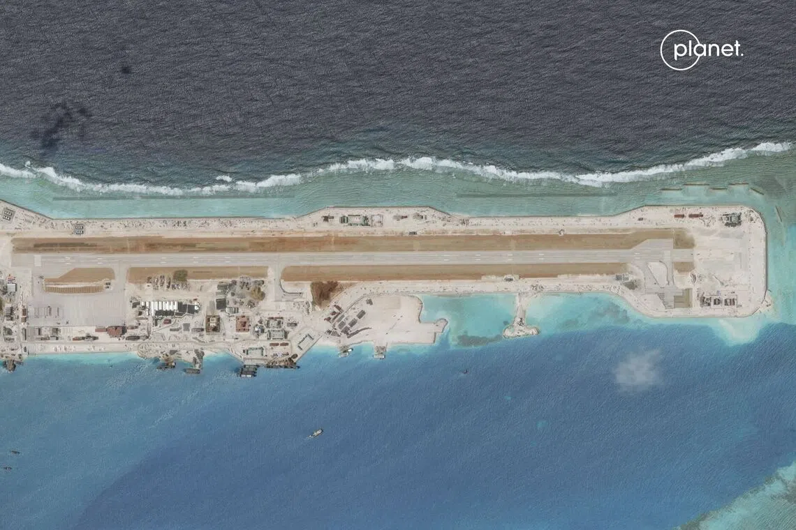
Barque Canada Reef, also known as Bai Thuyen Chai and Bai Jiao, is claimed by Vietnam, China, Taiwan and Malaysia. Located in the Spratly Islands, the reef is occupied by Vietnam, which added 58ha to it in 2025 alone.
PHOTO: PLANET LABS PBC
With historical narratives subject to interpretation and contestation – and potentially coloured by competing political agendas today – questions about historical claims may never be truly settled.
Bill Hayton, an associate fellow at British think-tank Chatham House and a long-time observer of South China Sea issues, said it is not possible to say that the sea belongs to any country.
“All you can do is say that a particular country has a better history of occupation over this particular feature. But you could go to the next feature one mile away and it would have a different history,” he said.
Hayton, who wrote a 2014 book on the South China Sea dispute, noted that history can be used selectively to make an exclusionary case – “by emphasising the bits that help your claim” – or it can be looked at from many different points of view to find a resolution.
He gave the example of how Singapore and Malaysia resolved their territorial dispute over Pedra Branca by agreeing to submit their competing historical evidence to a neutral process and ultimately abiding by the outcome.
Hayton said this could potentially be done for the South China Sea dispute, if the governments were willing.
“But they would have to be prepared to tell their own populations that this was in the wider interests of regional peace, and that they may not get everything that they want.
“The question is whether those governments would think that that was a good thing to do, or is it more useful to them to have these narratives,” he added.
Borderlands: Stretching from Myanmar and Vietnam in the south to Russia and Kazakhstan in the north, China’s 22,000km border is a mix of opportunities and friction. The Straits Times’ foreign correspondents go on the ground to map China’s complex relationship with those on its periphery. Read more about cross-strait ties, Central Asia and China-Vietnam border towns.
Produced by Chang May Choon, Albert Wai, Sharon Loh, Billy Ker, Lee Yu Hui and Yu Sheng Sin.