
SEOUL – The year’s strongest typhoon so far stormed across the southern parts of South Korea and Japan late on Monday, forcing both nations to cancel flights, and shut factories, offices and schools.
South Korea’s weather agency warned there could be casualties, as the most powerful storm in the nation's history slowly made its way towards the resort island of Jeju.
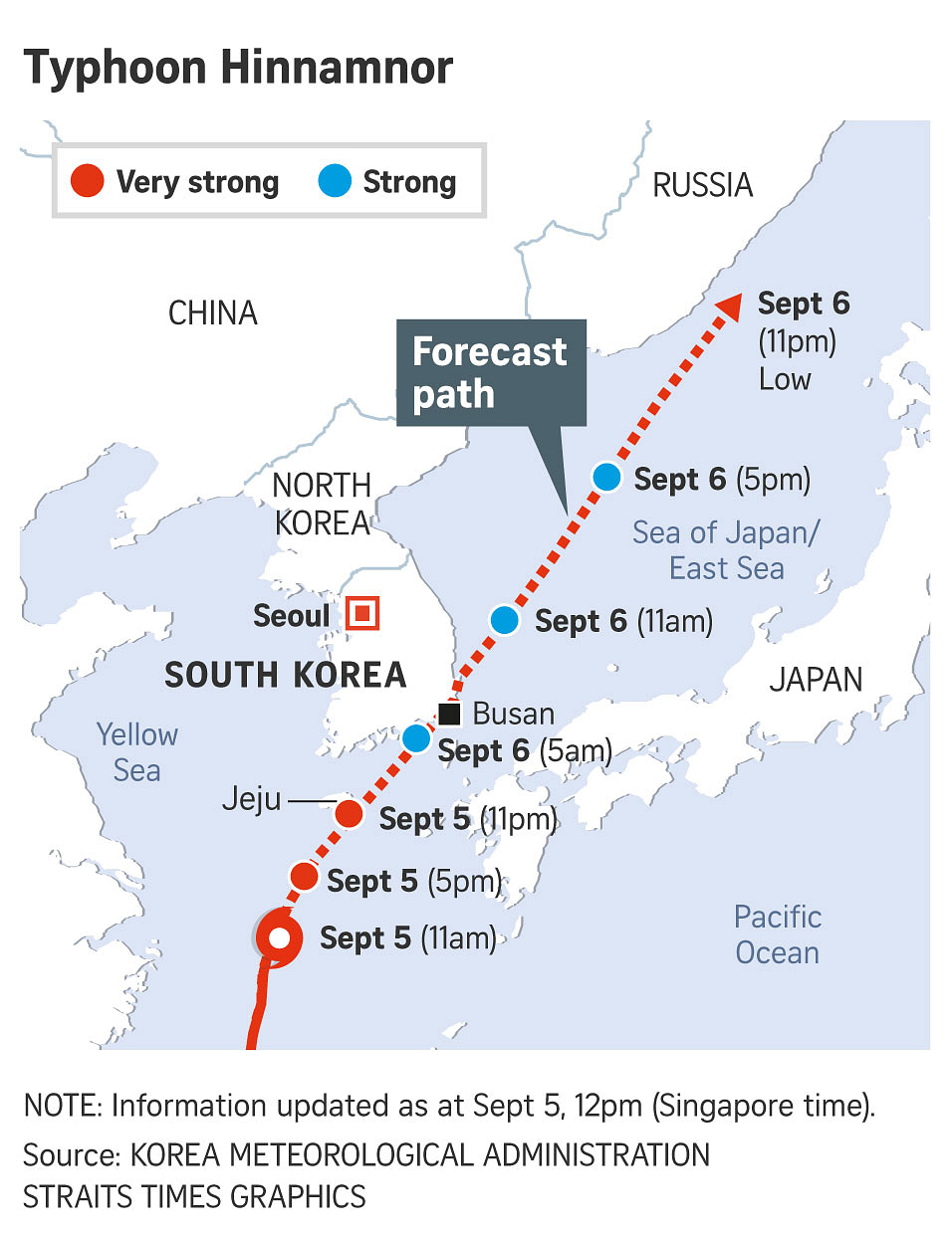
Typhoon Hinnamnor - moving at 24kmh - was already pounding parts of the westernmost island of Kyushu in Japan with heavy rain and hurricane-force winds, as it headed towards South Korea, which raised its typhoon-alert level to its highest level.
Hinnamnor was expected to make landfall south-west of the port city of Busan early Tuesday, after reaching waters off Jeju Island later on Monday.
President Yoon Suk-yeol said he would be on emergency standby, a day after ordering the authorities to put all efforts into minimising damage from the typhoon that has been classified as “very strong”.
“We’re now entering a phase where we have to minimise casualties,” Mr Han Sang Un, the chief forecaster at Korea Meteorological Administration (KMA), said during a briefing Monday
He urged residents of southern coastal areas to remain indoors rather than to continue making last-minute preparations for the storm’s arrival.
“It’s a massive typhoon with a 400km radius, which is big enough to cover Seoul to Busan. Most regions in Korea will experience intense rain and wind,” he said.
The typhoon was forecast to be more destructive than Typhoon Sarah that raked across South Korea in 1959.
According to KMA’s forecast, Hinnamnor was headed north-east toward Sapporo, Japan.
Some 70 flights were cancelled Monday in Japan.
Toyota Motor said it would suspend some evening shifts at three plants in western Japan, while Nissan Motor and Nissan Shatai subsidiaries in Fukuoka prefecture were expected to suspend production for Monday night and the Tuesday daylight shifts.
South Korea classifies typhoons in four categories – normal, strong, very strong, super strong – and Hinnamnor is expected to reach the country as a “very strong” typhoon, according to the KMA.
Typhoons under that classification have wind speeds of up to 53 metres per second.
Warnings have been issued across the southern cities, including Gwangju, Busan, Daegu and Ulsan, following that in the southern island of Jeju, while the Central Disaster and Safety Countermeasures Headquarters on Sunday upgraded its typhoon alert level to the highest in its four-tier system, the first time in five years.
Busan city and its neighbouring areas have received rain throughout the weekend, with more rain forecast across the wider country for Monday and Tuesday.
No casualties have been reported so far, though more than 100 people have been evacuated and at least 11 facilities have been damaged by floods.
Steelmaker Posco told Reuters it was considering suspending some of its production processes in the city of Pohang on Tuesday, while SK Innovation, owner of South Korea’s top refiner SK Energy, said it asked carrier ships not to operate until the typhoon passes.
Responding to local media reports over the planned halts of their operations, South Korean shipbuilders Korea Shipbuilding & Offshore Engineering, Daewoo Shipbuilding & Marine Engineering (DSME) and Samsung Heavy Industries, DSME said a decision on suspending its operations will be made later on Monday.
Korean Air Lines and Asiana Airlines have cancelled most of their Monday flights to Jeju Island, according to their websites, while budget airlines such as Air Seoul and Jin Air have cancelled some of their flights. REUTERS, BLOOMBERG