-
Getting there
-
Not many international airlines fly to Belfast. The best way to get there is via Scotland's Glasgow International Airport. Low-cost carrier flybe (www.flybe.com) operates several daily flights from there to the George Best Belfast City Airport.
An alternative is to fly to Dublin in Ireland, then take a bus or train to Belfast, a journey that takes two to 21/2 hours.
Getting around
Exploring Belfast is best done by jumping onto a Hop-On, Hop-Off bus which takes in the city's main sights, including distant attractions such as the Stormont Parliament Buildings, where the Good Friday Agreement that ended sectarian strife was signed, and also the fairy tale-like 19th-century Belfast Castle.
Stop at any of the 20 attractions listed to explore to your heart's content, then hop onto the next bus to continue sightseeing.
Bus tickets are £12.50 (S$23) for an adult, valid for two days (www.city-sightseeing.com). And, you get a voucher that entitles you to as much as £3 off the entrance fee to some of the paid attractions.
Belfast is a walkable city and many sights in the city centre can be reached on foot.
Discover Northern Ireland's lush green glens and scenic towns
Northern Ireland offers natural attractions such as green glens and coastal walks, and city walls filled with political murals


Northern Ireland was under the radar of most travellers because of The Troubles, decades of sectarian violence starting from the late 1960s, when protests and bombings were frequent.
The strife was the result of divided opinion. The Catholic nationalists felt that Northern Ireland should be part of Ireland, while the Protestant loyalists wanted it to remain part of the United Kingdom.
The Troubles finally subsided in 1998 when both sides signed the Good Friday Agreement, which called for an end to violence.
Tourists are trickling back and The Troubles - now a historical event - has enriched the country's past.
From lush green glens to wild coastal walks, scenery is Northern Ireland's main appeal and the Game Of Thrones fantasy television series chose several scenic film locations there.
But there is also a buzzing vibe in the restaurants, pubs and music scene. Its capital city Belfast also fascinates with its history, heritage and architecture.
Colourful murals depicting the political and religious rifts during The Troubles now draw travellers.
In Belfast, they are best seen in the neighbourhoods of Shankill (a bastion for Protestant loyalists) and the Falls (a stronghold of Catholic nationalists), located next to each other but separated by a high wall topped with barbed wire dubbed the "peace line".
Exploring these neighbourhoods gives glimpses of the Irish Tricolour or Union Jack draped in front of homes, hinting at the residents' loyalties and showing how divided the city was - and to some extent - still is.
More startling are the political murals in pretty Derry, also known as Londonderry, Northern Ireland's second city near the border with Ireland. The powerful images painted on buildings, depicting troubling events in the gritty Bogside district, are clearly seen on a walk along the ramparts.
Bogside walking tours, offering a closer look at the murals, leave daily from the tourist information counter at the Guildhall just outside the city walls.
HOME OF THE TITANIC
In its heyday, Belfast was a thriving town, thanks to its linen and shipbuilding industries in the 19th century.
Entering the city, my eyes are drawn to the towering cranes of the Harland & Wolff Shipyards. This was where the Titanic, the world's largest and most luxurious ocean liner then, was designed, built and launched in April 1912.
A boat tour of the abandoned docklands (www.laganboatcompany.com) gives an idea of how the Titanic must have looked like when she sailed out from the enormous slipway, that can still be seen, to begin her fateful maiden voyage that culminated in her hitting an iceberg in the North Atlantic Ocean and sinking.
In April 2012, a century later, at the edge of this same slipway is Titanic Belfast (www.titanicbelfast.com), built as part of an effort to regenerate the Belfast waterfront.
Reminiscent of the ship's hull, its four wedge-like structures soaring upwards contain nine interactive galleries that capture the Titanic story. Using special effects and animation, the interpretative exhibits revisit Belfast's shipbuilding boom years in the early 1900s and reveal what she might have looked like inside, with recreations of cabins, for instance.
Most poignant are the displays in Gallery Six, portraying the sinking of the Titanic with the sound of SOS messages in Morse code sent to other ships and the voices of survivors recounting their ordeal.
Equally moving is the exhibit in the last gallery presenting the Titanic lying 3,700m below the surface of the Atlantic Ocean, with a fish-eye view of the wreck under a glass floor.
ARCHITECTURAL RICHES
Belfast's industrial prosperity fuelled a building boom that has left the city with many Victorian and Edwardian landmarks.
Chief among them is the massive City Hall in the heart of Belfast, a Renaissance-style building that a free 45-minute daily guided tour reveals to be richly ornate.
To the side of the City Hall is a memorial garden dedicated to Titanic victims.
Then there is the Crown Liquor Saloon dating to 1826, which stands out for its opulently carved wooden interior, decorative bar tiles and "snugs" - 10 individual booths where patrons can drink in privacy, with a gun metal plate outside used by smokers in the past for striking matches.
Along the same street is the Grand Opera House (www.goh.co.uk) next to the equally grand Europa Hotel, both bombed during The Troubles and now restored to their former glory.
Buying a ticket to a show is the usual way to enter the Grand Opera House to view its lavish interior, but I approached the box-office receptionist who, in friendly Irish fashion, let me into the theatre on a day when there were no rehearsals.
I was astounded by the exotic Oriental touches to its richly painted ceiling with turbaned images and elephant heads decorating the private boxes.
Another architectural institution is the Victorian market of St George's, open on weekends and offering a mix of fresh produce, arts and crafts, food stalls and live music.
For more music, head to the Cathedral Quarter, a hot spot for dining and nightlife. This former warehousing district and home of newspaper offices is styled as Belfast's cultural hub, with many beer gardens, restaurants and bars.
One of the most popular is the historic Duke of York pub, known for its musical gigs. Its all-mirror interior is often crowded so patrons gather outside on the benches to admire art installations on either side of the alley.
SCENIC COASTAL DRIVE
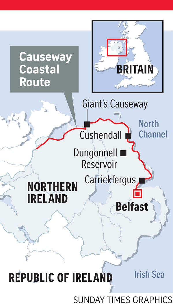
A short drive out of Belfast takes me to County Antrim, with the finest coastline in all of Ireland.
Forming part of the 190km Causeway Coastal Route, the top attraction is the Giant's Causeway, but there are many other worthwhile stops.
One of them is the well-preserved 12th-century Norman castle in the seaside town of Carrickfergus, the ancestral home of Andrew Jackson, America's seventh president.
From here, the road continues to Larne, hugging the Antrim coastline all the way to the north.
This winding route, completed in the 1840s, is hailed an engineering feat as the road is built between craggy rock faces and the sea, offering exhilarating views of headlands and sweeping bays as it skirts around them.
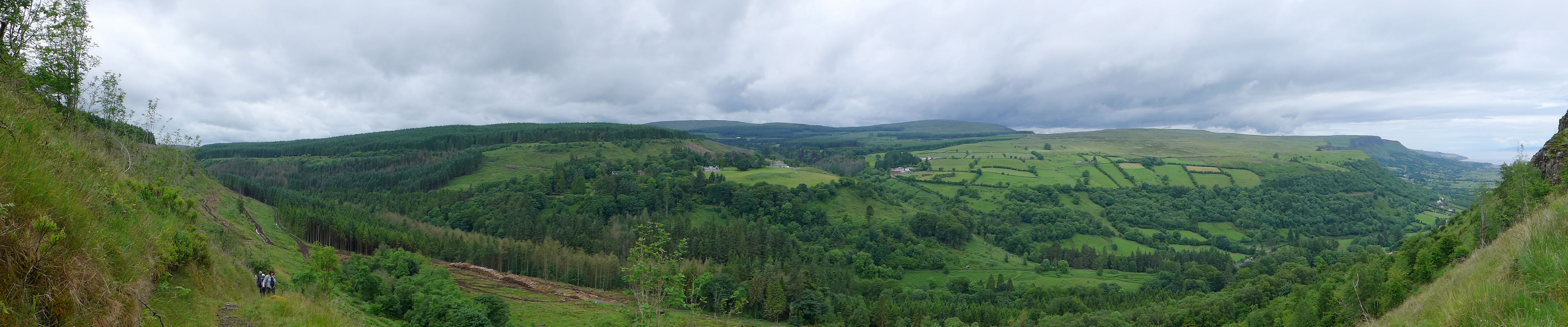
The road passes through the famous Nine Glens of Antrim, a place of immense natural beauty and perfect for hiking. The glens are narrow valleys radiating from the interior highlands to the sea and dotted with towns and villages.
I stayed for a week in one of these towns, Cushendall, to hike in the glens with a walking group (www.ramblers.co.uk).
Cushendall is known for its Georgian buildings. It also has a lively night scene with traditional Irish music and singing. The set-up is casual and spontaneous, with locals turning up nightly with a fiddle, accordion, flute and occasional harp. The top pub for this is McCollams (www.mccollamsbar.com).
WILD WALKS
It was late spring and on our walks in the glens, we were rewarded with carpets of an incredible array of flowers.
Though not particularly difficult, conditions were often boggy because of frequent rain, but we were compensated with gorgeous views, often from the tops of cliffs where we could take in panoramic coastal vistas.
On one hike, we could see as far as Scotland, just 16km over the sea.
Three walks, in particular, stood out. One centred on Glenariff, dubbed the "Queen of the Glens". So captivating is its beauty that 19th-century English novelist William Thackeray called it a Switzerland in miniature.
Starting at Dungonnell Reservoir, a 40-minute drive from Cushendall, we walked across bogs before ascending to a forested area thick with conifers, where trees were being felled. Below us was the Glenariff Forest Park and on our descent, we encountered the lovely but deadly foxglove flowers - known for its poisonous sap - various orchid species and buttercups.
At the bottom, we had a picnic lunch beside the Eis Crubb waterfall. From here, we took the Waterfalls Walk, a scenic trail on wooden walkways along a river that had carved out a deep gorge. It led to more gushing cascades and the most striking was the double-drop Ess-na-Larach Waterfall.
Just as outstanding was the walk along part of the Ulster Way, a circular 1,000km hiking trail that goes around the whole of Northern Ireland.
Reaching the slope of the volcanic plug of Sallagh Braes, we found ourselves in a bowl-like amphitheatre of green-clad cliffs. From the top, we looked out to the lovely bay of Ballygalley ahead of us and to the Slemish Mountains to our rear.
The story goes that St Patrick, the patron saint of Ireland, lived six years in these mountains tending to sheep as an enslaved young shepherd.
SWAYING SUSPENSION BRIDGE
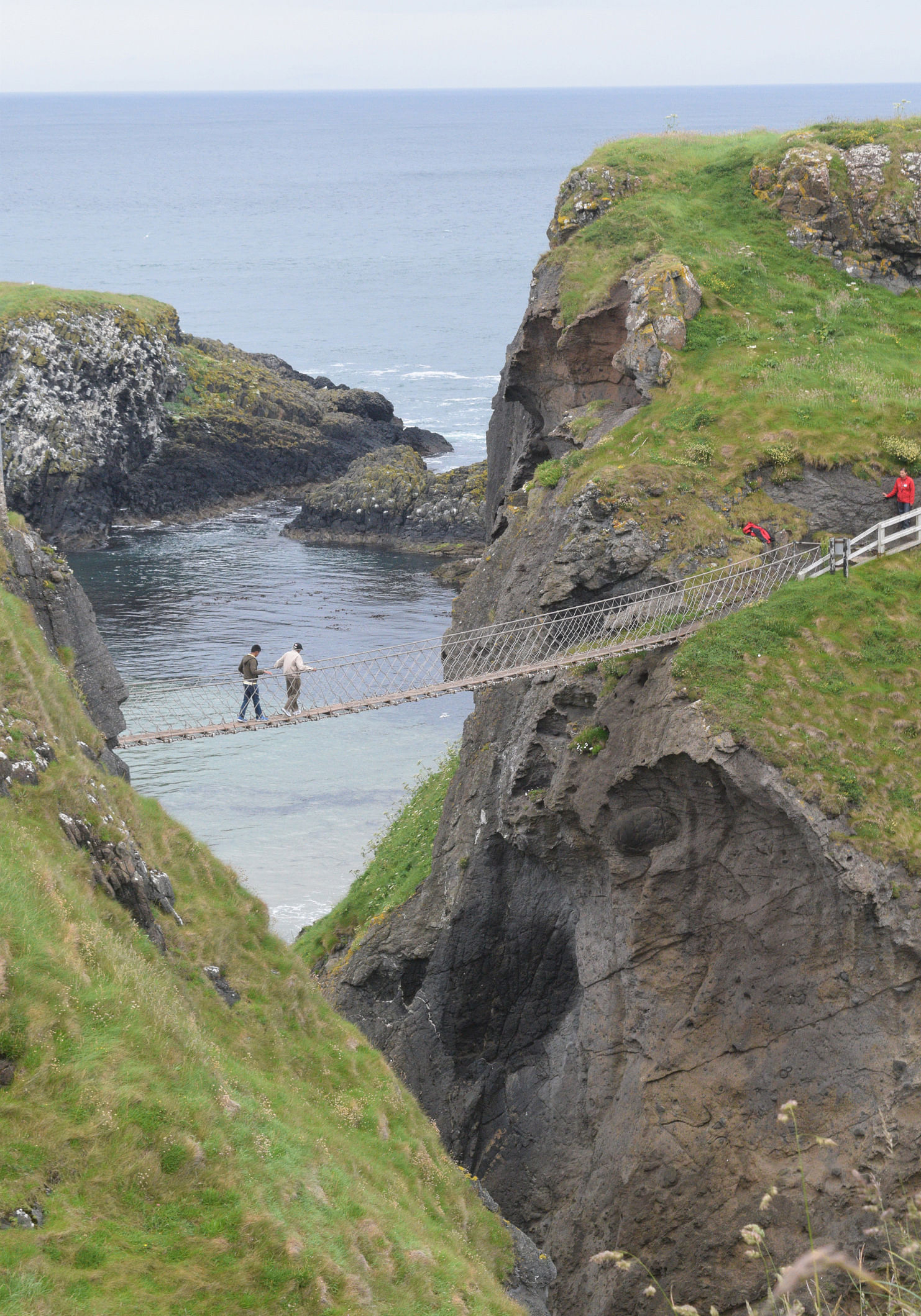
But the highlight of the Antrim coast was undoubtedly the walk to the Giant's Causeway and just before that, the Carrick-a-Rede Rope Bridge.
For centuries, this part of Northern Ireland was a point of Atlantic salmon migration between the mainland and the tiny island of Carrick-a-Rede and nets were hung across to catch them.
To check on their nets and bring in their haul, the fishermen first relied on boats, then decided to set up a rope bridge in 1755. They strung a rope bridge - covered by wooden planks and with a single handrail - 30m above the churning sea to get across a 20m chasm.
The bridge was last used in 2002 with the closure of the salmon fishery. Today, a wire suspension bridge with two handrails spans the same abyss, providing a safer, though no less exciting crossing, especially in gusty winds.
The 30-minute hike to the Carrick-a-Rede bridge from its starting point at Larrybane covers less than 2km. It is a lovely coastal trail overlooking steep, jagged, cove-studded chalk cliffs rising sharply from the sea.
There are views of Sheep Island and, beyond it, the larger Rathlin Island, the only inhabited offshore island in Northern Ireland and famous for its seabirds and seaweed farms.
From afar, the swaying bridge can be seen and the view of people crossing the yawning divide is something to behold and the moment to be cherished.
Then came my turn to accomplish the walk. Steady does it and I was across in no time.
GIANT'S CAUSEWAY
Just 15km from the rope bridge is the highlight, the Giant's Causeway.
The 6km coastal walk there started at Dunseverick Castle, now in ruins. The undulating trail across green meadows offers views of sheer basaltic cliffs with ribbed vertical sides, high bluffs wrapped around sweeping bays and foaming Atlantic waters.
After a few hours, we saw black rocky headlands with people, looking like ants, walking on the ridges ahead of us. That must be the Giant's Causeway, we thought, as we descended to the coast to get to the promontories and beach.
Then, there it was - about 40,000 basalt columns scattered along the shore and out into the sea. From above, they resemble giant hexagonal stepping stones, as if someone had fitted them together into a massive jigsaw puzzle.
Viewed from the side, they appear to be columns of tubes of different sizes that someone had stacked neatly side by side.
But this Unesco World Heritage Site is no man-made wonder. It is the powerful handiwork of nature - the result of a volcanic eruption 60 million years ago, which caused huge lava flows to solidify into basalt pillars as they cooled in the sea.
Local legend attributes the creation of the site to two giants, the Irish Finn McCool and his Scottish counterpart, Benandonner.
The story goes that Finn McCool built the causeway to go over to Scotland to duel with his arch-rival. But when he saw how huge the Scotsman was, McCool scurried back.
Benandonner followed and found McCool sleeping at home. Asking Mrs McCool if that was her husband, the quick-witted wife said no, that was her baby.
The Scottish giant thought that if the baby was that big, the father must be a true giant. Terrified of meeting McCool, he hurried back to Scotland, destroying the causeway along the way.
As I stepped onto the giant stones to get to the farthest pillars at sea, it was not difficult to imagine that perhaps, they had indeed been hurled out by a giant - a magical touch to the end of one of Northern Ireland's best wild walks.
•Tan Chung Lee is a freelance travel writer.
Join ST's Telegram channel and get the latest breaking news delivered to you.
A version of this article appeared in the print edition of The Sunday Times on September 18, 2016, with the headline Discover Northern Ireland's lush green glens and scenic towns . Subscribe