NEW DELHI • In the days leading up to the most violent border clash between India and China in decades, China brought in pieces of machinery, cut a trail into a Himalayan mountainside and may have even dammed a river, satellite pictures suggest.
The images, shot on Tuesday, a day after soldiers engaged in hand-to-hand combat in the freezing Galwan Valley, show an increase in activity from a week earlier.
India said 20 of its soldiers were killed in a premeditated attack by Chinese troops on Monday night, at a time when top commanders had agreed to defuse tensions on the Line of Actual Control (LAC), a poorly defined border between the nuclear-armed neighbours.
China rejected the allegations and blamed front-line Indian soldiers for provoking the conflict which took place at the freezing height of 4,300m in the western Himalayas.
The 4,056km border between India and China runs through glaciers, snow deserts and rivers in the west to thickly forested mountains in the east. The Galwan Valley is an arid, inhospitable area, where some soldiers are deployed on steep ridges.
It is considered important because it leads to the Aksai Chin, a disputed plateau claimed by India but controlled by China.
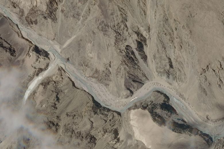
The satellite pictures, taken by Earth-imaging company Planet Labs and obtained by Reuters, show signs of the landscape of the valley being altered through widening tracks, moving earth and making river crossings, one expert said.
The images show machinery along the bald mountains and in the Galwan River. "Looking at it in Planet, it looks like China is constructing roads in the valley and possibly damming the river," said Dr Jeffrey Lewis, director of the East Asia Nonproliferation Programme at California's Middlebury Institute of International Studies.
"There are a tonne of vehicles on both sides (of the LAC) - although there appear to be vastly more on the Chinese side.
"I count 30 to 40 Indian vehicles and well over 100 vehicles on the Chinese side."
Chinese Foreign Ministry spokesman Zhao Lijian said he was unaware of the specifics on the ground but reiterated that the Indian army had crossed into Chinese territory in several places in recent days and that they should withdraw.
The clash was the most serious since 1967. Since early last month, soldiers have faced off on the border where India says Chinese troops had intruded and set up temporary structures. The confrontation turned into a deadly brawl on Monday.
The fighting was triggered by a row over two Chinese tents and observation towers that India said had been built on its side of the LAC, according to Indian government sources in New Delhi and on the Indian side of the border in the Ladakh region.
The problem arose when an Indian patrol visited the area near a ridge to verify a Chinese assertion that its troops had moved back from the LAC, the two government sources aware of the military situation said. The Chinese troops had thinned out and left behind the two tents and small observation posts.
The Indian party demolished the towers and burnt the tents, the sources said. The satellite images show possible debris from the observation posts on Tuesday morning on a ridge on India's side of the LAC. There was no such structure in the image taken a week earlier.
A large group of Chinese soldiers arrived and confronted the Indian troops.
REUTERS