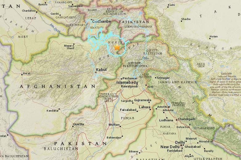
KABUL (AFP, REUTERS) - A 6.6-magnitude quake struck north-east Afghanistan on Sunday (April 10), the US Geological Survey said, with tremors also felt in Pakistan and India.
The quake at a depth of 210km occurred at 2.58pm (6.28pm Singapore time), 282 km north-east of the capital Kabul, in a remote area near the border with Pakistan.
One man was killed in Pakistan's mountainous northern region of Gilgit-Baltistan when he was hit by falling
rocks in the town of Chilas, an official told AFP on condition of anonymity.
The quake was felt for a few seconds in Kabul and in Pakistan's capital Islamabad, where some residents evacuated apartment blocks after tremors shook ceiling fans and furniture.
People in the Pakistani city of Lahore, 630km from the epicentre, also reported they had felt the tremors.
A Reuters witness in Chitral, Pakistan, said the tremor was strong but there was no major damage visible.
The quake was also felt in the Indian capital New Delhi, where buildings in the centre swayed and the metro train system was halted temporarily as a precaution. People rushed out of their homes in the northern region of Indian-administered Kashmir.
"People are on the streets now and we don't know whether to go back inside," said an AFP reporter in Kashmir's main city of Srinagar.
Last October, a 7.5-magnitude quake ripped across Pakistan and Afghanistan, killing almost 400 people and flattening buildings in rugged terrain that impeded relief efforts.